IMAGES TAKEN NEAR TO
Chawleigh, CHULMLEIGH, EX18 7ET
Introduction
This page details the photographs taken nearby to EX18 7ET by members of the Geograph project.
The Geograph project started in 2005 with the aim of publishing, organising and preserving representative images for every square kilometre of Great Britain, Ireland and the Isle of Man.

There are currently over 7.5m images from over14,400 individuals and you can help contribute to the project by visiting https://www.geograph.org.uk
Image Map
Images are licensed for reuse under creativecommons.org/licenses/by-sa/2.0
Notes
- Clicking on the map will re-center to the selected point.
- The higher the marker number, the further away the image location is from the centre of the postcode.
Image Listing (13 Images Found)
Images are licensed for reuse under creativecommons.org/licenses/by-sa/2.0
Image
Details
Distance
1
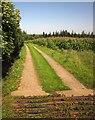
Footpath, Rodgemonts
Chawleigh Footpath 15 leaves Rodgemonts Lane across this cattle grid and follows the track to Rodgemonts and Rodgemonts Wood past a field of maize.
Image: © Derek Harper
Taken: 22 Aug 2013
0.08 miles
2
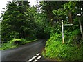
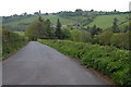
Mid Devon : Chawleigh Hill B3096
Looking along Chawleigh Hill from Darky Lane.
Image: © Lewis Clarke
Taken: 13 Jun 2019
0.08 miles
4
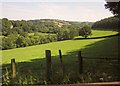
The Little Dart River Valley
View up the Little Dart River valley to the east of Chulmleigh.
Image: © Philip Halling
Taken: 14 May 2006
0.12 miles
5
Chulmleigh viewed from across the Little Dart River valley
Chulmleigh viewed from the Chawleigh road on the southern side of the Little Dart River valley. In common with many villages in this area the village is situated on high ground and has a prominent church tower.
Image: © Philip Halling
Taken: 14 May 2006
0.14 miles
6
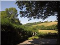
Little Dart Valley
This is the view shown in Image, seven and a bit years on, from Rodgemonts Cross. That must be a quarry face in Park Mill Wood on the left, but it's not shown on any map. On the right is Cleave's Wood.
Image: © Derek Harper
Taken: 22 Aug 2013
0.16 miles
7
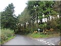
Chawleigh Hill
The B3096 turns sharply to the right as it drops to cross the Little Dart River, which is followed by the trees along the valley floor. The road then climbs steeply to Chulmleigh, whose church can be seen ahead, in Image The trees on the left form part of Chawleigh Week Wood.
Image: © Derek Harper
Taken: 22 Aug 2013
0.21 miles
8

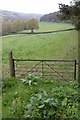
Bridge over the Little Dart south-east of Chulmleigh
Image: © Sarah Charlesworth
Taken: 24 Jan 2010
0.22 miles
10
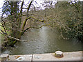
Looking up the Little Dart River from Chulmleigh Bridge
Image: © Roger A Smith
Taken: 27 Feb 2015
0.24 miles