IMAGES TAKEN NEAR TO
Chevithorne, TIVERTON, EX16 7QR
Introduction
This page details the photographs taken nearby to EX16 7QR by members of the Geograph project.
The Geograph project started in 2005 with the aim of publishing, organising and preserving representative images for every square kilometre of Great Britain, Ireland and the Isle of Man.

There are currently over 7.5m images from over14,400 individuals and you can help contribute to the project by visiting https://www.geograph.org.uk
Image Map (Loading...)


Getting Data...Please wait
Leaflet Map data © OpenStreetMap
Images are licensed for reuse under creativecommons.org/licenses/by-sa/2.0
Notes
- Clicking on the map will re-center to the selected point.
- The higher the marker number, the further away the image location is from the centre of the postcode.
Image Listing (15 Images Found)
Images are licensed for reuse under creativecommons.org/licenses/by-sa/2.0
Image
Details
Distance
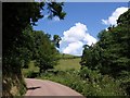
1
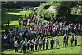
Mid Devon : Walking Across Mud
The perambulation takes you all over the place. Here they try and navigate around some mud.
Image: © Lewis Clarke
Taken: 11 Sep 2010
0.05 miles
2
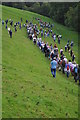
Mid Devon : Hone Hill & Walkers
The walk heads out onto rough terrain here and until it reaches Norwood Common. http://www.tivertonpeople.co.uk/news/Hundreds-perambulate-town-leat-historic-day/story-7101998-detail/story.html
Image: © Lewis Clarke
Taken: 11 Sep 2010
0.09 miles
3
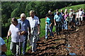
Mid Devon : Hone Hill & Tivertonians
The people of Tiverton gather on the hillside to be read the proclamation of the leat http://www.tivertonpeople.co.uk/news/Hundreds-perambulate-town-leat-historic-day/story-7101998-detail/story.html
Image: © Lewis Clarke
Taken: 11 Sep 2010
0.14 miles
4
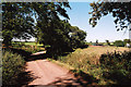
Tiverton: the old Bampton Road
Looking north from near Firebeacon. This was the main route between Tiverton and Bampton until the new Exe Valley road – the A396 – was opened in 1819. It was further downgraded in the 1860s when Knighthayes House was built; the replacement road was constructed away from the house, running to the east via Allers and Chettiscombe
Image: © Martin Bodman
Taken: 2 Sep 2005
0.16 miles
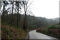
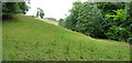
6
Lane up Town Leat valley
The lane just above the scene in Image, curving away from the main valley and about to ascend a side valley to the left. Across the hillside ahead, emerging from Hone Copse, is the farm road to Hone. Allers Wood is on the right.
Image: © Derek Harper
Taken: 8 Jul 2009
0.18 miles
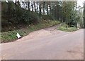
8
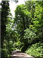
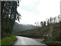
Road through the woods
The road passes between Gatcombe Copse (left) and Hone Copse (right), a fine trees border it. This is just north of the point at which Image has veered away from the main valley and is beginning to climb a side valley.
Image: © Derek Harper
Taken: 8 Jul 2009
0.19 miles
9
Mid Devon : Rolling Hills
This is a place where in 2003 we stopped on this hill while the man read out a proclamation.
Image: © Lewis Clarke
Taken: 20 Jul 2008
0.20 miles