IMAGES TAKEN NEAR TO
Willand, CULLOMPTON, EX15 2RF
Introduction
This page details the photographs taken nearby to EX15 2RF by members of the Geograph project.
The Geograph project started in 2005 with the aim of publishing, organising and preserving representative images for every square kilometre of Great Britain, Ireland and the Isle of Man.

There are currently over 7.5m images from over14,400 individuals and you can help contribute to the project by visiting https://www.geograph.org.uk
Image Map
Images are licensed for reuse under creativecommons.org/licenses/by-sa/2.0
Notes
- Clicking on the map will re-center to the selected point.
- The higher the marker number, the further away the image location is from the centre of the postcode.
Image Listing (36 Images Found)
Images are licensed for reuse under creativecommons.org/licenses/by-sa/2.0
Image
Details
Distance
1
Parked coaches, old A38
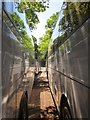
After the recent trials along the course of this public access route (see Image), what a joy to have nothing more serious ahead than squeezing between these coaches on what is now a layby of the B3181. It had taken me 20 minutes to cover less than 400 metres, so it would have much quicker to stick to the main road, but just think of what I'd have missed!
Image: © Derek Harper
Taken: 26 May 2012
0.06 miles
4

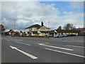
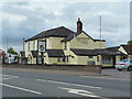
The Halfway House, B3181, north of Willand
Image: © David Smith
Taken: 5 Apr 2017
0.07 miles
5
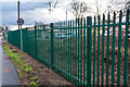
Willand : Fence
A steel fence along the road.
Image: © Lewis Clarke
Taken: 15 Jan 2019
0.08 miles
6
Bank of nettles, former A38
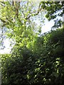
The only picture I took (too busy dealing with it) of the final obstacle along the public access route shown in Image and Image This would probably have been simple to cross a few weeks earlier, but the astonishingly fast growing Urtica Dioica had covered it to a height of over a metre, obscuring the steep banks on either side. Without a proper stick it took me well over 10 minutes to batter my way across and descend this western side safely.
Image: © Derek Harper
Taken: 26 May 2012
0.08 miles
7

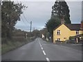
Filling station by B3181 north of Willand
Image: © David Smith
Taken: 5 Apr 2017
0.09 miles
8
Willand : Uffculme Road, B3440
A road heading between Willand and Uffculme.
Image: © Lewis Clarke
Taken: 19 Nov 2015
0.11 miles
9
Fields by the old A38
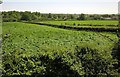
The view from the top of the gravel heap blocking the public access route shown in Image is better than from ground level (Image), which seems fair compensation for having to climb it. The houses are along the B3340 Uffculme Road.
Image: © Derek Harper
Taken: 26 May 2012
0.12 miles
