IMAGES TAKEN NEAR TO
Butterleigh, CULLOMPTON, EX15 1PR
Introduction
This page details the photographs taken nearby to EX15 1PR by members of the Geograph project.
The Geograph project started in 2005 with the aim of publishing, organising and preserving representative images for every square kilometre of Great Britain, Ireland and the Isle of Man.

There are currently over 7.5m images from over14,400 individuals and you can help contribute to the project by visiting https://www.geograph.org.uk
Image Map
Images are licensed for reuse under creativecommons.org/licenses/by-sa/2.0
Notes
- Clicking on the map will re-center to the selected point.
- The higher the marker number, the further away the image location is from the centre of the postcode.
Image Listing (14 Images Found)
Images are licensed for reuse under creativecommons.org/licenses/by-sa/2.0
Image
Details
Distance
1
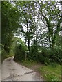
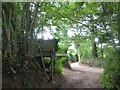
Footpath signed off the track to Shutelake Farm
Image: © David Smith
Taken: 16 Aug 2017
0.09 miles
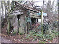
3
Ruined shed
The shed stands at a crossroads; the paved road turns through a right angle, and is joined by a bridleway (to Shutelake Farm) and footpath (to Birchen Oak at Image])
Image: © David Smith
Taken: 20 Jan 2012
0.13 miles
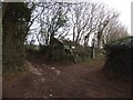
4
End of a track and a ruined garage
The remains of a wooden garage are at the bend in the paved road and the end of the lane
Image: © David Smith
Taken: 16 Aug 2017
0.14 miles
5

Signs of road widening and realignment
In the bank are the stumps of three trees. Presumably these were felled to make the road wider and the bend easier to negotiate, and the trees behind planted to replace them
Image: © David Smith
Taken: 16 Aug 2017
0.15 miles
6
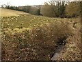
Stream, Butterleigh
A tributary of the Burn River, seen from the lane which crosses the river near their junction. Looking downstream, with a rushy meadow to the left.
Image: © Derek Harper
Taken: 16 Mar 2010
0.20 miles
8
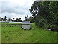
A mixed field south of Butterleigh
On the left, solar panels; in the centre, an anonymous hut; on the right, a cattle trough
Image: © David Smith
Taken: 16 Aug 2017
0.21 miles
9
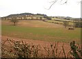
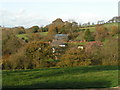
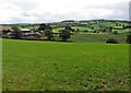
Valley east of Butterleigh
From the lane into the village from East Butterleigh Cross. The hilltop Hillersdon Wood is in Image / Image
Image: © Derek Harper
Taken: 16 Mar 2010
0.21 miles