IMAGES TAKEN NEAR TO
Marsh, HONITON, EX14 9AN
Introduction
This page details the photographs taken nearby to EX14 9AN by members of the Geograph project.
The Geograph project started in 2005 with the aim of publishing, organising and preserving representative images for every square kilometre of Great Britain, Ireland and the Isle of Man.

There are currently over 7.5m images from over14,400 individuals and you can help contribute to the project by visiting https://www.geograph.org.uk
Image Map
Images are licensed for reuse under creativecommons.org/licenses/by-sa/2.0
Notes
- Clicking on the map will re-center to the selected point.
- The higher the marker number, the further away the image location is from the centre of the postcode.
Image Listing (4 Images Found)
Images are licensed for reuse under creativecommons.org/licenses/by-sa/2.0
Image
Details
Distance
1
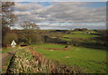
Yarcombe: Clifthayne Farm
The farm stands high up above the Yarty valley although just sheltered from the prevailing winds. Looking north east
Image: © Martin Bodman
Taken: 29 Aug 2006
0.16 miles
3
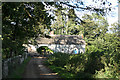
Towards the Yarty valley
The lane descends the western slopes of the Yarty valley. Cinder Hill Farm, across the valley on the right, is in Image, as is the woodland left of centre on Longlie Common.
Image: © Derek Harper
Taken: 25 Feb 2012
0.20 miles
4
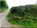
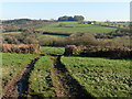
Channel to Channel (196)
The sign and track to New Barn Farm are passed.
Image: © Shazz
Taken: 17 Sep 2014
0.21 miles