IMAGES TAKEN NEAR TO
Awliscombe, HONITON, EX14 3NN
Introduction
This page details the photographs taken nearby to EX14 3NN by members of the Geograph project.
The Geograph project started in 2005 with the aim of publishing, organising and preserving representative images for every square kilometre of Great Britain, Ireland and the Isle of Man.

There are currently over 7.5m images from over14,400 individuals and you can help contribute to the project by visiting https://www.geograph.org.uk
Image Map
Images are licensed for reuse under creativecommons.org/licenses/by-sa/2.0
Notes
- Clicking on the map will re-center to the selected point.
- The higher the marker number, the further away the image location is from the centre of the postcode.
Image Listing (11 Images Found)
Images are licensed for reuse under creativecommons.org/licenses/by-sa/2.0
Image
Details
Distance
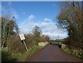
1
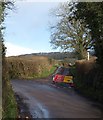
Lane junction near Awliscombe
The closed lane is Tape Lane; to the left is Weston Lane, which connects Weston to Awliscombe.
Image: © Derek Harper
Taken: 26 Jan 2012
0.10 miles
2
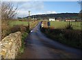
Weston Lane
A similar view to Image, looking up the lane from Cherry Bridge towards Kains Park Farm in Image Beyond are houses on the A373 east of Awliscombe.
Image: © Derek Harper
Taken: 26 Jan 2012
0.11 miles
3
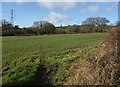
Grass field by the Wolf
The River Wolf runs along the left side of this field; Tape Lane runs along the far side in this image and fords the river before passing the pylon. The view is from Weston Lane.
Image: © Derek Harper
Taken: 26 Jan 2012
0.12 miles
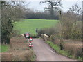
5
Cherry Bridge
A view of Image from the other direction. The bridge carries Weston Lane over the River Wolf.
Image: © Derek Harper
Taken: 26 Jan 2012
0.13 miles
6
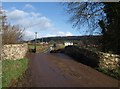
Cherry Bridge
Image: © Derek Harper
Taken: 26 Jan 2012
0.13 miles
7

River Wolf from Cherry Bridge
Image: © Derek Harper
Taken: 26 Jan 2012
0.14 miles
8
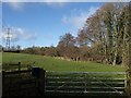
Meadow by the Wolf
From the gateway on the left of Image, with trees, including alder, along the river on the right (looking upstream).
Image: © Derek Harper
Taken: 26 Jan 2012
0.15 miles
9
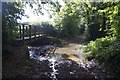
Ford at Weston
This ford is found on Tape Lane, a byway running between Dunkeswell and Buckerell.
http://youtu.be/3NFwDnDLN40
Image: © John Walton
Taken: 26 Sep 2014
0.17 miles
10
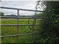
Awliscombe : Grassy Field & Gate
A gate with a grassy field beyond.
Image: © Lewis Clarke
Taken: 10 Aug 2023
0.24 miles