IMAGES TAKEN NEAR TO
Combpyne Road, AXMINSTER, EX13 8AR
Introduction
This page details the photographs taken nearby to Combpyne Road, EX13 8AR by members of the Geograph project.
The Geograph project started in 2005 with the aim of publishing, organising and preserving representative images for every square kilometre of Great Britain, Ireland and the Isle of Man.

There are currently over 7.5m images from over14,400 individuals and you can help contribute to the project by visiting https://www.geograph.org.uk
Image Map
Images are licensed for reuse under creativecommons.org/licenses/by-sa/2.0
Notes
- Clicking on the map will re-center to the selected point.
- The higher the marker number, the further away the image location is from the centre of the postcode.
Image Listing (71 Images Found)
Images are licensed for reuse under creativecommons.org/licenses/by-sa/2.0
Image
Details
Distance
1

Musbury: the village stores
Village store and post office, in the centre of the village but a short distance from the main road.
Image: © Chris Downer
Taken: 10 Oct 2011
0.04 miles
2
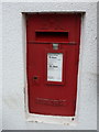
Musbury: postbox № EX13 52
This Elizabeth II-reign postbox is set quite deeply into the wall of Image
Image: © Chris Downer
Taken: 10 Oct 2011
0.05 miles
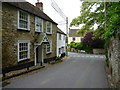
3

Rosemary Lane, Musbury
Cottages along a little back street in the village. On the right, a high wall of stone surmounted by cob.
Image: © Derek Harper
Taken: 15 Sep 2012
0.05 miles
5

It's rather steep
A sign for this footpath advises no horses.
Image: © Anthony Vosper
Taken: 29 Aug 2024
0.06 miles
6
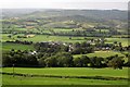
Musbury
The village seen from Musbury Footpath 32 along the crest of the scarp slope, with the Axe valley beyond. In the middle distance on the right is Whitford, and over the wooded knoll of Langdown Plantation is the Umborne Brook valley.
Image: © Derek Harper
Taken: 15 Sep 2012
0.08 miles
7
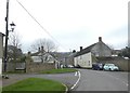
The Street, Musbury
One of the main streets in the village; above the rooftops one can see the line of trees on the hill to the east
Image: © David Smith
Taken: 30 Dec 2019
0.08 miles
8
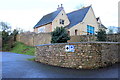
Musbury Village School
The primary school is at the top of Church Hill adjacent to the parish church and it appears to have been recently refurbished. it also has an ample new car park.
Image: © Nigel Mykura
Taken: 27 Jan 2017
0.09 miles
9
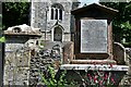
Musbury, St. Michael's Church: War memorial
Image: © Michael Garlick
Taken: 21 Jun 2022
0.09 miles