IMAGES TAKEN NEAR TO
Shute, AXMINSTER, EX13 7QW
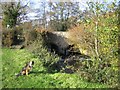
Introduction
This page details the photographs taken nearby to EX13 7QW by members of the Geograph project.
The Geograph project started in 2005 with the aim of publishing, organising and preserving representative images for every square kilometre of Great Britain, Ireland and the Isle of Man.

There are currently over 7.5m images from over14,400 individuals and you can help contribute to the project by visiting https://www.geograph.org.uk
Image Map
Images are licensed for reuse under creativecommons.org/licenses/by-sa/2.0
Notes
- Clicking on the map will re-center to the selected point.
- The higher the marker number, the further away the image location is from the centre of the postcode.
Image Listing (25 Images Found)
Images are licensed for reuse under creativecommons.org/licenses/by-sa/2.0
Image
Details
Distance
1
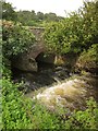
Easy Bridge
Easy Bridge over the Umborne Brook.
Image: © Rupert Fleetingly
Taken: 19 Nov 2006
0.11 miles
2

Umborne Brook
Looking upstream as the river winds sinuously between meadows and trees. Shute Footpath 8 runs alongside at this point.
Image: © Derek Harper
Taken: 28 Aug 2012
0.12 miles
3

Umborne Brook
Looking upstream from Shute Footpath 8 below Easy Bridge. The turbulent water below the weir at the bridge can be glimpsed at the bend on the left.
Image: © Derek Harper
Taken: 28 Aug 2012
0.12 miles
4
Easy Bridge
A detail of the scene in Image The Umborne Brook emerges from below the bridge and crosses a small weir.
Image: © Derek Harper
Taken: 28 Aug 2012
0.13 miles
5
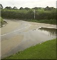
Easy Bridge Cross
The T-juncstion in the background of Image, with a large puddle.
Image: © Derek Harper
Taken: 28 Aug 2012
0.13 miles
6
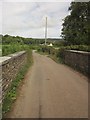
Easy Bridge
Lodge Lane crosses Image] and runs across the Umborne Brook flood plain. Just past the house in the background it passes beneath the Waterloo-Exeter railway line.
Image: © Derek Harper
Taken: 28 Aug 2012
0.13 miles
7

Shute: at Easy Bridge
Over the bridge, which crosses the Umborne Brook, the lane to the left runs on to Colyton. Watchcombe is reached by turning right
Image: © Martin Bodman
Taken: 6 Dec 2006
0.13 miles
8
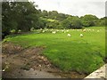
Sheep and cattle by the Umborne Brook
See Image; this view of the same animals was taken from the lane a few metres west of Image The Waterloo-Exeter railway line can be seen on its embankment in the background.
Image: © Derek Harper
Taken: 28 Aug 2012
0.14 miles
9
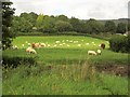
By the Umborne Brook
Taken from Easy Bridge (Image) looking upstream, with a mixture of sheep and cattle grazing on the other bank.
Image: © Derek Harper
Taken: 28 Aug 2012
0.14 miles
10

Umborne Brook
The river is flowing, fairly powerfully, to the right. Across the field beyond is the embankment of the Exeter-Waterloo railway line.
Image: © Derek Harper
Taken: 28 Aug 2012
0.17 miles