IMAGES TAKEN NEAR TO
Shute, AXMINSTER, EX13 7QL
Introduction
This page details the photographs taken nearby to EX13 7QL by members of the Geograph project.
The Geograph project started in 2005 with the aim of publishing, organising and preserving representative images for every square kilometre of Great Britain, Ireland and the Isle of Man.

There are currently over 7.5m images from over14,400 individuals and you can help contribute to the project by visiting https://www.geograph.org.uk
Image Map
Images are licensed for reuse under creativecommons.org/licenses/by-sa/2.0
Notes
- Clicking on the map will re-center to the selected point.
- The higher the marker number, the further away the image location is from the centre of the postcode.
Image Listing (23 Images Found)
Images are licensed for reuse under creativecommons.org/licenses/by-sa/2.0
Image
Details
Distance
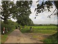
2
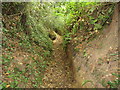
Muddy Field near Pressing Iron and Shears Farm
The strangely named nearby farm appears to have got its name from an inn (public house) that stood near to the stream that runs through this field.
Image: © Nigel Mykura
Taken: 29 Feb 2020
0.09 miles
3
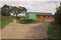
Umborne Institute Hall
Not the container, but the building behind it, which was opened in October 2011, after the removal of the Quonset Hut which had stood here for the previous 62 years http://umborne.org/2011/10/umborne-hall-annual-report-2010-21011/ . This is at a lane junction; the road behind the camera is a dead end leading to Big Umbourne.
Image: © Derek Harper
Taken: 28 Aug 2012
0.10 miles
4
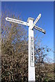
Signpost at Pottlelake.
This wooden signpost points the direction to Umborne, Watchcombe and Colyton.
Image: © Nigel Mykura
Taken: 29 Feb 2020
0.11 miles
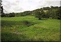
5
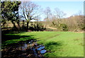
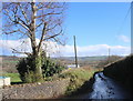
Lane near Umborne
The lane to Easy Bridge Cross runs along the Umborne Brook valley past trees, hedges and fields. The parapet fence on the left indicates that the lane crosses a tiny stream here, which joins the brook nearby to the left.
Image: © Derek Harper
Taken: 28 Aug 2012
0.11 miles
6
Umborne Brook valley
From the no through road to Big Umbourne; one has a "u" and one hasn't. The cottage at Little Umbourne is on the lane between the railway bridges at Penny Corner and Patches.
Image: © Derek Harper
Taken: 28 Aug 2012
0.13 miles
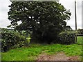
8
Stile near Umborne
On Shute Footpath 14, the footpath running alongside the lane from Umborne towards Easy Bridge Cross.
Image: © Derek Harper
Taken: 28 Aug 2012
0.16 miles
9
Lane near Pope's Cross
This lane is known as Chapel Knap and it runs from Coxley Lane up to Watchcombe
Image: © Nigel Mykura
Taken: 29 Feb 2020
0.18 miles
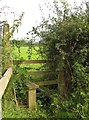
10
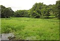
Meadow by the Umborne Brook
From the lane between Easy Bridge and Umborne. The unseen river is winding, from right to left, past the trees.
Image: © Derek Harper
Taken: 28 Aug 2012
0.18 miles