IMAGES TAKEN NEAR TO
Tolcis, AXMINSTER, EX13 7JF
Introduction
This page details the photographs taken nearby to EX13 7JF by members of the Geograph project.
The Geograph project started in 2005 with the aim of publishing, organising and preserving representative images for every square kilometre of Great Britain, Ireland and the Isle of Man.

There are currently over 7.5m images from over14,400 individuals and you can help contribute to the project by visiting https://www.geograph.org.uk
Image Map
Images are licensed for reuse under creativecommons.org/licenses/by-sa/2.0
Notes
- Clicking on the map will re-center to the selected point.
- The higher the marker number, the further away the image location is from the centre of the postcode.
Image Listing (9 Images Found)
Images are licensed for reuse under creativecommons.org/licenses/by-sa/2.0
Image
Details
Distance
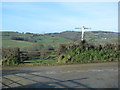
2
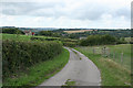
View towards Tolcis Cross
Tolcis Cross is the road junction marked by the hedgerows in the centre distance of the image behind the tall tree. This is the reverse image of Image
Image: © Nigel Mykura
Taken: 7 Aug 2015
0.15 miles
4
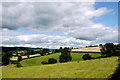
Axminster: towards the Yarty valley
Looking west-north-west from Tolcis Cross. On the skyline stands the communications mast at Stockland Hill TV Station; just visible on this image
Image: © Martin Bodman
Taken: 1 Sep 2006
0.18 miles
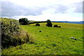
5
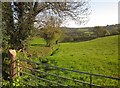
Field boundary below Tolcis Hill
A view from the lane between Tolcis Cross and Wellands Cross. Yeatlands Coppice can be seen further down the hillside towards the Yarty valley.
Image: © Derek Harper
Taken: 16 May 2013
0.18 miles
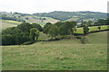
7

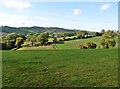
Field below Tolcis Farm
Looking down the other side of the field boundary shown in Image], with the Yart valley ahead.
Image: © Derek Harper
Taken: 16 May 2013
0.20 miles
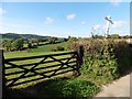
8
View From Tolcis Cross
This is the view from Tolcis Cross north west towards Ashcroft, which is the white house in the centre of the image. This is the reverse image to Image
Image: © Nigel Mykura
Taken: 7 Aug 2015
0.22 miles
9
Membury: near Hasland Farm
View at the point where a public footpath leaves the driveway and heads across a field towards Lewsley Cross. Looking north-north-west.
Image: © Martin Bodman
Taken: 1 Sep 2006
0.23 miles