IMAGES TAKEN NEAR TO
Coles Lane, AXMINSTER, EX13 5SB
Introduction
This page details the photographs taken nearby to Coles Lane, EX13 5SB by members of the Geograph project.
The Geograph project started in 2005 with the aim of publishing, organising and preserving representative images for every square kilometre of Great Britain, Ireland and the Isle of Man.

There are currently over 7.5m images from over14,400 individuals and you can help contribute to the project by visiting https://www.geograph.org.uk
Image Map
Images are licensed for reuse under creativecommons.org/licenses/by-sa/2.0
Notes
- Clicking on the map will re-center to the selected point.
- The higher the marker number, the further away the image location is from the centre of the postcode.
Image Listing (21 Images Found)
Images are licensed for reuse under creativecommons.org/licenses/by-sa/2.0
Image
Details
Distance
1

Lower Beavor
On Axminster Footpath 17, approaching the farm, with a wood on the left.
Image: © Derek Harper
Taken: 23 Nov 2013
0.01 miles
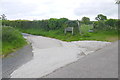
2
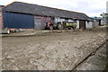
Farmyard Lower Beavor Farm
This is the main yard of the dairy farm through which a footpath runs
Image: © Nigel Mykura
Taken: 23 May 2015
0.02 miles
3
Lower Beavor Farm
This is a dairy farm with a small holstein herd of cattle
Image: © Nigel Mykura
Taken: 23 May 2015
0.02 miles
4
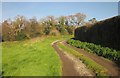
Track to Lower Beavor
Axminster Footpath 17 follows this track, which has been established fairly recently, from Coles's Lane. On the left is the wood also shown in Image
Image: © Derek Harper
Taken: 23 Nov 2013
0.09 miles
5
Pasture and wood, Lower Beavor
From a gateway on Axminster Footpath 17. The wood is unnamed on maps.
Image: © Derek Harper
Taken: 23 Nov 2013
0.11 miles
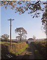
6
New Access to Lower Beavor Farm
This concrete track is relatively new and does not show up on current maps and google earth satellite images (May 2015). It runs from Cole's lane to Lower Beavor and runs along the line of an older footpath.
Image: © Nigel Mykura
Taken: 23 May 2015
0.12 miles
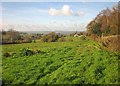
7
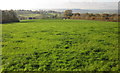
Field, Lower Beavor
A grass field beside Axminster Footpath 17. The distant field boundary on the right borders Sector Hill. On the left is the north side of the wood shown in Image Beyond is the Mill Brook valley.
Image: © Derek Harper
Taken: 23 Nov 2013
0.14 miles
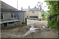
8
Coles's Lane
A no through road, here approaching a corrugated iron barn with curved roof.
Image: © Derek Harper
Taken: 23 Nov 2013
0.15 miles
9
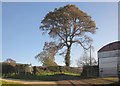
Coles's Lane
A closer view of the oak and barn seen in Image A recently-created farm road into Lower Beavor leaves on the left, followed by Axminster Footpath 17.
Image: © Derek Harper
Taken: 23 Nov 2013
0.15 miles
10
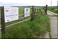
Beavor or Beaver?
All the maps and other evidence indicate that it is the modern plastic sign that is incorrectly spelt. at the entrance to the track leading to the farm.
Image: © Nigel Mykura
Taken: 23 May 2015
0.16 miles