IMAGES TAKEN NEAR TO
Riverside Way, SEATON, EX12 2UE
Introduction
This page details the photographs taken nearby to Riverside Way, EX12 2UE by members of the Geograph project.
The Geograph project started in 2005 with the aim of publishing, organising and preserving representative images for every square kilometre of Great Britain, Ireland and the Isle of Man.

There are currently over 7.5m images from over14,400 individuals and you can help contribute to the project by visiting https://www.geograph.org.uk
Image Map
Images are licensed for reuse under creativecommons.org/licenses/by-sa/2.0
Notes
- Clicking on the map will re-center to the selected point.
- The higher the marker number, the further away the image location is from the centre of the postcode.
Image Listing (314 Images Found)
Images are licensed for reuse under creativecommons.org/licenses/by-sa/2.0
Image
Details
Distance
1
Riverside Way
Leading to an industrial estate at the east of Seaton.
Image: © John Lucas
Taken: 20 Feb 2024
0.02 miles
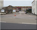
2

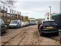
Riverside Way
Cul-de-sac off Harbour Road leading to a small industrial estate. Old maps suggest that this was once railway land, including the railway goods yard on the right. The 1968-73 1:2,500 map, after closure of the railway, is the first to mark the road, but unmamed, and shows the area on the right housing an "Electronic Engineering Factory", with a coal yard on the left. The 1980-89 edition, the first to name the road, shows the factory to have expanded (although no longer naming it) and the development of the light industrial units as "Riverside Workshops" in the left background. I have separately discovered that the electronics factory was operated by Racal Electronics, who used the site for defence communications work. It closed in 2000 following the loss of a major contract and the site was demolished in 2008. In this photo, the workshops remain, but the area on the right is still derelict.
Image: © Ian Capper
Taken: 8 Feb 2020
0.04 miles
3

Boatyard at Seaton
Looking across the River Axe.
Image: © Jonathan Thacker
Taken: 15 Sep 2017
0.05 miles
4
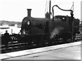
M7 locomotive 30048 takes water at Seaton
M7 class locomotive 30048 has its tanks filled with water at Seaton, before working the next train to Seaton Junction. The bridge over the River Axe seen in the left background was built in 1877, and is the oldest concrete bridge in Britain.
Image: © Richard Green
Taken: 20 Apr 1963
0.05 miles
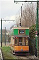
5
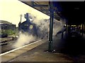
Seaton station with a train for Seaton Junction
A push-pull train hauled by a M7 class locomotive awaits departure from Seaton.
Image: © Richard Green
Taken: 2 Apr 1963
0.05 miles
6
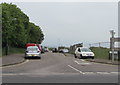
Riverside Way, Seaton
A dead-end road on the north side of Harbour Road, Riverside Way
leads to Riverside Workshops on the west bank of the River Axe.
Image: © Jaggery
Taken: 20 May 2018
0.06 miles
7
Entrance to Harcombe Trailer Centre and Harcombe Engineering, Seaton
From the north side of Harbour Road.
Image: © Jaggery
Taken: 20 May 2018
0.07 miles
8
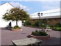
Lyme Bay Holiday Village, Seaton
Part of the village that has not yet been knocked down to make way for a new Tesco store.
Image: © Nigel Mykura
Taken: 18 Sep 2008
0.07 miles
10
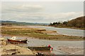
Seaton: River Axe Estuary
View up the estuary in the direction of Axmouth
Image: © Mr Eugene Birchall
Taken: 12 Mar 2007
0.08 miles