IMAGES TAKEN NEAR TO
Kings Avenue, OTTERY ST. MARY, EX11 1TA
Introduction
This page details the photographs taken nearby to Kings Avenue, EX11 1TA by members of the Geograph project.
The Geograph project started in 2005 with the aim of publishing, organising and preserving representative images for every square kilometre of Great Britain, Ireland and the Isle of Man.

There are currently over 7.5m images from over14,400 individuals and you can help contribute to the project by visiting https://www.geograph.org.uk
Image Map
Images are licensed for reuse under creativecommons.org/licenses/by-sa/2.0
Notes
- Clicking on the map will re-center to the selected point.
- The higher the marker number, the further away the image location is from the centre of the postcode.
Image Listing (14 Images Found)
Images are licensed for reuse under creativecommons.org/licenses/by-sa/2.0
Image
Details
Distance
1
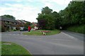
Kennaway Road/Chineway Road, Ottery St Mary
Junction of Kennaway Road and Chineway Road, Ottery St Mary, Devon.
Image: © Kevin Hale
Taken: 13 Jun 2006
0.04 miles
2

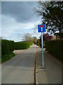
Higher Ridgeway, Ottery St Mary
This green lane leads from Ottery St Mary Footpath 27 into the town.
Image: © Derek Harper
Taken: 13 Aug 2010
0.19 miles
3
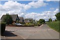
Orange Way in Devon and Torbay (383)
The road is now designated as a dead end as further along (past the houses) it becomes an unsurfaced track.
Image: © Shazz
Taken: 16 Apr 2012
0.19 miles

5

Longdogs Lane meets Slade Road
The housing estates of Ottery St. Mary.
The long wooded ridge of East Hill beyond.
Image: © Jonathan Billinger
Taken: 26 Mar 2010
0.20 miles

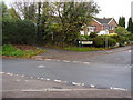
7
Higher Ridgeway, Ottery St Mary
Chalet bungalows by the junction of Higher Ridgeway with Kennaway Road.
Image: © Derek Harper
Taken: 13 Aug 2010
0.22 miles
8

Longdogs Lane, Ottery St Mary
From its junction with Slade Road, Longdogs Lane climbs past a junction with Grandisson Drive before dropping steadily towards the town centre.
Image: © Derek Harper
Taken: 13 Aug 2010
0.22 miles
9
Bridlepath to Knightstone
Situated off Longdogs Lane.
The name Longdog is derived from a process used to cut timber. Timber was cut over a pit with a Longdog a type of saw. One man stood in the pit and one above the pit.
From which we get the expression topdog. The man who didn't get covered in sawdust, was the topdog.
Image: © Anthony Vosper
Taken: 13 Nov 2010
0.22 miles
10
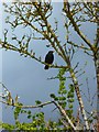
Orange Way in Devon and Torbay (382)
This blackbird caught my eye with the clouds behind him.
Image: © Shazz
Taken: 16 Apr 2012
0.22 miles