IMAGES TAKEN NEAR TO
Blackthorn Close, SIDMOUTH, EX10 9XR
Introduction
This page details the photographs taken nearby to Blackthorn Close, EX10 9XR by members of the Geograph project.
The Geograph project started in 2005 with the aim of publishing, organising and preserving representative images for every square kilometre of Great Britain, Ireland and the Isle of Man.

There are currently over 7.5m images from over14,400 individuals and you can help contribute to the project by visiting https://www.geograph.org.uk
Image Map
Images are licensed for reuse under creativecommons.org/licenses/by-sa/2.0
Notes
- Clicking on the map will re-center to the selected point.
- The higher the marker number, the further away the image location is from the centre of the postcode.
Image Listing (57 Images Found)
Images are licensed for reuse under creativecommons.org/licenses/by-sa/2.0
Image
Details
Distance
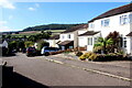
1
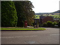
Stowford rise junction with Hawthorn close.
A Post box and telephone box serve the local community.
Image: © Anthony Vosper
Taken: 17 Sep 2009
0.01 miles
2
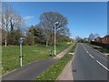
Why stop here?
The end of a cycle lane in Stowford Rise; doubtless many cyclists ignore the sign and continue along the path
Image: © David Smith
Taken: 4 Apr 2014
0.03 miles
3
A work in progress
Extension work being carried out on the Beacon Health Centre.
Sedemunda Close.
Image: © Anthony Vosper
Taken: 28 Feb 2023
0.08 miles
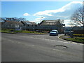
4

The Beacon Medical Centre
A purpose built centre complete with pharmacy.
This replaces the Sedemuda Centre.
Image: © Anthony Vosper
Taken: 25 Jun 2016
0.09 miles
5
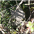
Old Milestone by the A3052, High Street, Sidmouth
Stone post (plate lost) by the A3052, in parish of SIDMOUTH (EAST DEVON District), High Street, 100m West of Core Hill Road and Waitrose supermarket entrance road (Stowford Rise), set well back in double hedge, among brambles, on North side of road. Lyme iron plate, erected by the Lyme Regis (Charmouth to Wimple) turnpike trust in the 19th century.
Inscription reads:-
LYME
15
EXETER
13
Carved benchmark and rivet on top.
Devon & Dartmoor HER.
HER Number: MDV76435 https://www.heritagegateway.org.uk/Gateway/Results_Single.aspx?uid=MDV76435&resourceID=104
Milestone Society National ID: DV_EXLR13.
Image: © Alan Rosevear
Taken: 7 Apr 2011
0.10 miles
6
Houses on Ladymead
Ladymead is on the housing estate on the very northwestern edge of Sidmouth close to the A3052.
Image: © Nigel Mykura
Taken: 23 Sep 2022
0.10 miles
7
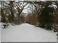
Core Hill Road
Deep in snow after 'Storm Emma'
Image: © Anthony Vosper
Taken: 2 Mar 2018
0.10 miles
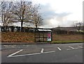
9
Pedestrian crossing, Stowford Rise.
A new style crossing. The poles light up as well. Whilst not clear the bus stop is on part of the crossing.
The building work in the background is part of the extension to Waitrose.
Image: © Anthony Vosper
Taken: 3 Sep 2009
0.11 miles
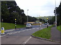
10

Core Hill road
Originally this would take you to the foot of Core Hill.
It is now a dead end due to the addition of Stowford Rise.
Image: © Anthony Vosper
Taken: 4 Jan 2022
0.11 miles