IMAGES TAKEN NEAR TO
North Street, WALTHAM ABBEY, EN9 2NW
Introduction
This page details the photographs taken nearby to North Street, EN9 2NW by members of the Geograph project.
The Geograph project started in 2005 with the aim of publishing, organising and preserving representative images for every square kilometre of Great Britain, Ireland and the Isle of Man.

There are currently over 7.5m images from over14,400 individuals and you can help contribute to the project by visiting https://www.geograph.org.uk
Image Map (Loading...)


Getting Data...Please wait
Leaflet Map data © OpenStreetMap
Images are licensed for reuse under creativecommons.org/licenses/by-sa/2.0
Notes
- Clicking on the map will re-center to the selected point.
- The higher the marker number, the further away the image location is from the centre of the postcode.
Image Listing (4 Images Found)
Images are licensed for reuse under creativecommons.org/licenses/by-sa/2.0
Image
Details
Distance
1
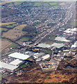
Peck's Hill at Lower Nazeing
Part of the Lea Valley horticultural area.
Image: © M J Richardson
Taken: 6 Feb 2018
0.03 miles
4

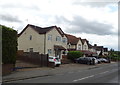
Meadow at Lower Nazeing
The land is probably part of the River Lea flood plain which would explain why it has not been developed. The houses in the distance on North Street are a little higher.
Image: © Stephen Craven
Taken: 15 Aug 2009
0.24 miles