IMAGES TAKEN NEAR TO
Honeywood Close, POTTERS BAR, EN6 5QE
Introduction
This page details the photographs taken nearby to Honeywood Close, EN6 5QE by members of the Geograph project.
The Geograph project started in 2005 with the aim of publishing, organising and preserving representative images for every square kilometre of Great Britain, Ireland and the Isle of Man.

There are currently over 7.5m images from over14,400 individuals and you can help contribute to the project by visiting https://www.geograph.org.uk
Image Map
Images are licensed for reuse under creativecommons.org/licenses/by-sa/2.0
Notes
- Clicking on the map will re-center to the selected point.
- The higher the marker number, the further away the image location is from the centre of the postcode.
Image Listing (7 Images Found)
Images are licensed for reuse under creativecommons.org/licenses/by-sa/2.0
Image
Details
Distance
1
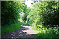
Bridleway to The Ridgeway
This is the northern end of the wide section of bridleway from The Ridgeway to Coopers Lane Road - capable of taking farm vehicles. Beyond this point (behind me) it becomes more like a footpath as it passes Five Acre Wood.
Image: © Martin Addison
Taken: 2 Jun 2010
0.21 miles
3
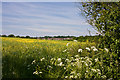
View Towards Potters Bar
Looking across a field of Rape from the Bridleway to Coopers Lane Road. The land slopes down here from Foxhole Hill on the left to the valley of a stream that becomes Turkey Brook and flows into the River Lea.
Image: © Martin Addison
Taken: 2 Jun 2010
0.22 miles
4
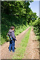
Sowing Dandelions
Kids can't resist the seed heads can they? The bridleway to Coopers Lane Road begins to dip down to cross a stream, though the effect of the perspective is to make this look up hill!
Image: © Martin Addison
Taken: 2 Jun 2010
0.22 miles
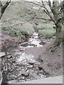
5
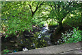
Stream Under the Bridleway
Crossed on a concrete bridge, this stream flows across the fields near Potters Bar to follow the route of the M25 - shouldn't that be the other way round? - and eventually becomes Turkey Brook before becoming part of a maze of waterways adjoining the New River in the Lee Valley Park and eventually, flowing into the River Lea (Lee) itself.
Image: © Martin Addison
Taken: 2 Jun 2010
0.23 miles
6
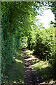
Bridleway to Coopers Lane Road
Passing beside Five Acre Wood, at this point the bridleway is just about wide enough for a single horse to pass.
Image: © Martin Addison
Taken: 2 Jun 2010
0.24 miles
7
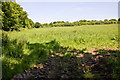
Field beside Five Acre Wood
Seen from the bridleway between The Ridgeway and Coopers Lane Road, the field is located between Five Acre Wood on the left and Fir Wood. The trees in the distance mark the route of Coopers Lane Road.
Image: © Martin Addison
Taken: 2 Jun 2010
0.24 miles