IMAGES TAKEN NEAR TO
Woodgate Avenue, POTTERS BAR, EN6 4EW
Introduction
This page details the photographs taken nearby to Woodgate Avenue, EN6 4EW by members of the Geograph project.
The Geograph project started in 2005 with the aim of publishing, organising and preserving representative images for every square kilometre of Great Britain, Ireland and the Isle of Man.

There are currently over 7.5m images from over14,400 individuals and you can help contribute to the project by visiting https://www.geograph.org.uk
Image Map
Images are licensed for reuse under creativecommons.org/licenses/by-sa/2.0
Notes
- Clicking on the map will re-center to the selected point.
- The higher the marker number, the further away the image location is from the centre of the postcode.
Image Listing (7 Images Found)
Images are licensed for reuse under creativecommons.org/licenses/by-sa/2.0
Image
Details
Distance
1
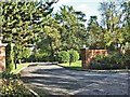
Woodgate Avenue, off Coopers Lane Road
Woodgate Avenue is a private road off Coopers Lane Road
Image: © Christine Matthews
Taken: 4 Nov 2005
0.07 miles
2
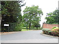
The entrance to Woodgate Avenue on Coopers Lane Road
Image: © David Howard
Taken: 18 Sep 2013
0.08 miles
3
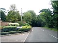
Coopers Lane Road at the junction of Woodgate Avenue
Image: © David Howard
Taken: 18 Sep 2013
0.08 miles
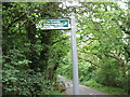
4
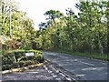
Junction of Woodgate Avenue and Coopers Lane Road
Road junction off Coopers Lane Road leading to Woodgate Avenue and Oakwell Drive, Northaw, Potters Bar.
Image: © Christine Matthews
Taken: 4 Nov 2005
0.08 miles
6
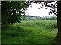
Pylons and farmland off Coopers Lane
You can see the M25 in the far distance.
Image: © Bikeboy
Taken: 10 Jun 2012
0.23 miles
7
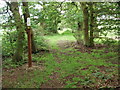
Footpath from Coopers Lane to Trent Park
The path goes over the M25.
Image: © Bikeboy
Taken: 10 Jun 2012
0.23 miles