IMAGES TAKEN NEAR TO
Blanche Lane, POTTERS BAR, EN6 3PD
Introduction
This page details the photographs taken nearby to Blanche Lane, EN6 3PD by members of the Geograph project.
The Geograph project started in 2005 with the aim of publishing, organising and preserving representative images for every square kilometre of Great Britain, Ireland and the Isle of Man.

There are currently over 7.5m images from over14,400 individuals and you can help contribute to the project by visiting https://www.geograph.org.uk
Image Map
Images are licensed for reuse under creativecommons.org/licenses/by-sa/2.0
Notes
- Clicking on the map will re-center to the selected point.
- The higher the marker number, the further away the image location is from the centre of the postcode.
Image Listing (44 Images Found)
Images are licensed for reuse under creativecommons.org/licenses/by-sa/2.0
Image
Details
Distance
1
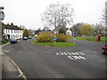
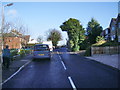
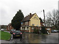
South Mimms: Blanche Lane
This is the roundabout at the junction of Blanche Lane with Greyhound Lane which is off to the right. The tower of Image is visible just to the left of the silver birch tree in the centre of the roundabout.
Image: © Nigel Cox
Taken: 29 Feb 2008
0.06 miles
2
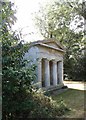
Cavendish Bentinck Mausoleum, South Mimms
Located in the churchyard of St Giles, South Mimms, the mausoleum was built in 1914 to the designs of architect Robert Weir Schultz. More at http://www.mmtrust.org.uk/mausolea/view/78/Cavendish_Bentinck_Mausoleum
Image: © Jim Osley
Taken: 18 Jul 2015
0.08 miles
3

Nineteenth century benchmark on church
This benchmark was established in 1848 during the First primary levelling of England & Wales, and was levelled with a height of 319.705 feet [97.446 metres] above mean sea level (Liverpool datum). It was included on the Birmingham to London levelling line. The surveyor's description was "No. 301. Bolt in South-west buttress of South Mims [sic] Church tower ; 1.62 ft. above sill of door." (Public Abstract p.228).
Image: © Shantavira
Taken: 7 Aug 2016
0.12 miles
5
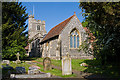
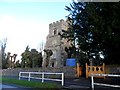
St. Giles, South Mimms
Parish Church of South Mimms, seen from within the churchyard. The church tower is at the Blanche Lane end. This view is from beside the footpath that leads from Blanche Lane to St. Albans Road, behind me.
The church is a nice example of a flint-knapped building. The chancel dates to the 13th century and the tower to circa 1450 (info from British History online).
Image: © Martin Addison
Taken: 10 May 2009
0.12 miles
7
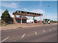
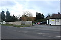
Disused petrol station, South Mimms
Another view at Image
Image: © Jim Osley
Taken: 19 Jul 2015
0.12 miles
8
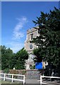
St Giles' church, South Mimms
C13 chancel, C14 tower, C15 nave.
Image: © Bikeboy
Taken: 19 Jan 2014
0.12 miles