IMAGES TAKEN NEAR TO
Stapylton Road, BARNET, EN5 4JH
Introduction
This page details the photographs taken nearby to Stapylton Road, EN5 4JH by members of the Geograph project.
The Geograph project started in 2005 with the aim of publishing, organising and preserving representative images for every square kilometre of Great Britain, Ireland and the Isle of Man.

There are currently over 7.5m images from over14,400 individuals and you can help contribute to the project by visiting https://www.geograph.org.uk
Image Map
Images are licensed for reuse under creativecommons.org/licenses/by-sa/2.0
Notes
- Clicking on the map will re-center to the selected point.
- The higher the marker number, the further away the image location is from the centre of the postcode.
Image Listing (221 Images Found)
Images are licensed for reuse under creativecommons.org/licenses/by-sa/2.0
Image
Details
Distance
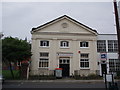
1
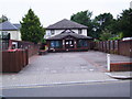
Longrove Surgery
Until recently on union street there were a doctor's surgery, a pub (http://www.geograph.org.uk/photo/2993946) and a church (http://www.geograph.org.uk/photo/2993937) all next door to each other-something all of life's eventualities . The pub in between the two has unfortunately closed.
Image: © Bikeboy
Taken: 14 Jun 2012
0.02 miles
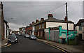
2
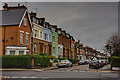
Salisbury Road
The houses with a mix of brick and pastel shdes stand out against the lowering clouds. The road running right to left and cutting Salisbury Road in two is Stapylton Road.
Image: © Martin Addison
Taken: 8 Nov 2009
0.04 miles
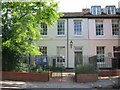
3
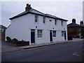
Former pub converted into housing
Until about 2008 this was the Albion pub. It has now been converted into housing and is called "Albion Cottages".
Image: © Bikeboy
Taken: 14 Jun 2012
0.05 miles
4
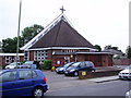
Catholic church of St Gregory and Mary Immaculate
Built in the late 60's to replace the original church was destroyed in a fire.
Image: © Bikeboy
Taken: 14 Jun 2012
0.05 miles
5
Former chapel in Union Street
Built as a chapel in 1889, now used as offices.
Image: © Bikeboy
Taken: 14 Jun 2012
0.06 miles
6
Union Street
Seen from the junction with Stapylton Road. Two single storey shop units are tagged onto the end of the terrace here. One remains in use whilst the other has been boarded up.
Image: © Martin Addison
Taken: 8 Nov 2009
0.07 miles
7
The Museum at Barnet
I didn't have time to check the contents
Website: www.barnetmuseum.co.uk
Image: © Jack Hill
Taken: 7 Jul 2005
0.08 miles
8
Wesley Hall High Barnet
Coming out of the fluorescently lit Spires shopping centre to the second floor car park my eyes had to adjust to the sunset. The spire of Wesley Hall dark against the fading light with an incongruous yellow shopping trolley park sign in the foreground.
Image: © John Kingdon
Taken: 1 Oct 2018
0.08 miles
9
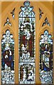
United Reformed Church, Wood Street, Barnet - Window
Image: © John Salmon
Taken: 23 Jan 2010
0.08 miles
10
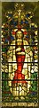
United Reformed Church, Wood Street, Barnet - Window
Image: © John Salmon
Taken: 23 Jan 2010
0.08 miles