IMAGES TAKEN NEAR TO
Whitworth Crescent, ENFIELD, EN3 6YG
Introduction
This page details the photographs taken nearby to Whitworth Crescent, EN3 6YG by members of the Geograph project.
The Geograph project started in 2005 with the aim of publishing, organising and preserving representative images for every square kilometre of Great Britain, Ireland and the Isle of Man.

There are currently over 7.5m images from over14,400 individuals and you can help contribute to the project by visiting https://www.geograph.org.uk
Image Map
Images are licensed for reuse under creativecommons.org/licenses/by-sa/2.0
Notes
- Clicking on the map will re-center to the selected point.
- The higher the marker number, the further away the image location is from the centre of the postcode.
Image Listing (46 Images Found)
Images are licensed for reuse under creativecommons.org/licenses/by-sa/2.0
Image
Details
Distance
1
Terrace, Government Row
Grade II listed. http://www.britishlistedbuildings.co.uk/en-511192-71-76-government-row-non-civil-parish-gr
Image: © N Chadwick
Taken: 3 Feb 2013
0.05 miles
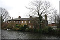
2
Houses at the end of Government Row
This terrace is the northernmost building on Enfield Island. The road comes to a dead end just beyond them, where the channels of the River Lea diverge.
Image: © Stephen Craven
Taken: 2 May 2009
0.05 miles
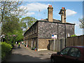
3
Terrace, Government Row
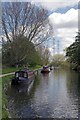
The northern extremity of the Row, running along the bank of the Lee Navigation and formerly housing workers in the small arms works that was once here.
Image: © Robin Webster
Taken: 20 Oct 2012
0.05 miles
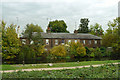
4
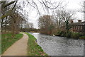
Cottages seen across the River Lee Navigation
The original River Lea flowed 70 miles from Leagrove Marsh near Luton to the River Thames at Bow Creek. The River Lee Act of 1766 provided for the construction of 15 new cuts to straighten the course of the river by eliminating loops which made it difficult to navigate. This is one of those cuts and hence it is a navigation rather than a river. The Lea passes just the other side of these workers' cottages which are in Government Row. Historically the river is spelled Lea while the navigation is Lee.
Beyond the River Lea is the new development of Enfield Island Village on the site of the former Royal Arms Factory which was given its formal title in 1854 and manufactured the famous Lee Enfield rifle which linked the two names associated with the spot.
Image: © Marathon
Taken: 27 Sep 2017
0.06 miles
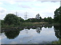
7
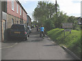
Government Row, Enfield
Although described as a private road (protected by barriers at each end), our group of cyclists was not challenged along here.
Image: © Stephen Craven
Taken: 2 May 2009
0.08 miles
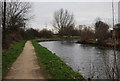
9
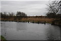
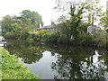
River Lee (or Lea) near Waltham Abbey
The River Lee (or Lea) flows behind the wooden barrier. The River Lee Navigation branches off here to the right.
Image: © Malc McDonald
Taken: 1 Jun 2013
0.10 miles