IMAGES TAKEN NEAR TO
Baddeley Close, ENFIELD, EN3 6WS
Introduction
This page details the photographs taken nearby to Baddeley Close, EN3 6WS by members of the Geograph project.
The Geograph project started in 2005 with the aim of publishing, organising and preserving representative images for every square kilometre of Great Britain, Ireland and the Isle of Man.

There are currently over 7.5m images from over14,400 individuals and you can help contribute to the project by visiting https://www.geograph.org.uk
Image Map
Images are licensed for reuse under creativecommons.org/licenses/by-sa/2.0
Notes
- Clicking on the map will re-center to the selected point.
- The higher the marker number, the further away the image location is from the centre of the postcode.
Image Listing (81 Images Found)
Images are licensed for reuse under creativecommons.org/licenses/by-sa/2.0
Image
Details
Distance
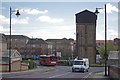
1
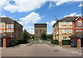
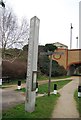
Water Tower, Enfield Island Village
Enfield Island Village is a new residential area on land which was formerly the Royal Small Arms Factory.
Various structures from the old factory have been retained in the new development.
Image: © Des Blenkinsopp
Taken: 24 Jul 2014
0.01 miles
3
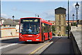
Arriva bus on route 491
Arriva's ENL10 leaves Enfield Island Village on route 491 bound for North Middlesex Hospital.
Image: © Peter Horrex
Taken: 25 Sep 2010
0.03 miles
4
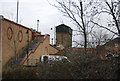
Enfield Island Village Water Tower
The water tower makes the entrance to this modern housing estate built on the site of the former Royal Small Arms Factory; see https://en.wikipedia.org/wiki/Enfield_Island_Village for more info.
Image: © Glyn Baker
Taken: 28 Apr 2016
0.04 miles
5
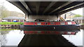
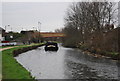
River Lee Navigation at Enfield Island Village
Image: © Christine Matthews
Taken: 12 Apr 2018
0.04 miles
6
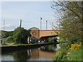
Ordnance Road bridge, Enfield
The bridge is a modern one, giving access over the Lea Navigation to an early 21st century housing estate (Enfield Island Village). The road name, like many in the area, has a military reference to the area's history - see http://en.wikipedia.org/wiki/Enfield_Island_Village
Image: © Stephen Craven
Taken: 2 May 2009
0.05 miles
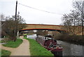
9
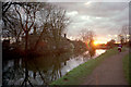
River Lee Navigation with Government Row cottages and cycle track
Looking towards the setting sun with a cyclist on the cycle track alongside the River Lee Navigation with the Government Row houses which were originally built to house the workers as the Small Arms Factory on the site which is now the Enfield Island Village Estate.
Image: © Christine Matthews
Taken: Unknown
0.06 miles