IMAGES TAKEN NEAR TO
Aldridge Avenue, ENFIELD, EN3 6HZ
Introduction
This page details the photographs taken nearby to Aldridge Avenue, EN3 6HZ by members of the Geograph project.
The Geograph project started in 2005 with the aim of publishing, organising and preserving representative images for every square kilometre of Great Britain, Ireland and the Isle of Man.

There are currently over 7.5m images from over14,400 individuals and you can help contribute to the project by visiting https://www.geograph.org.uk
Image Map
Images are licensed for reuse under creativecommons.org/licenses/by-sa/2.0
Notes
- Clicking on the map will re-center to the selected point.
- The higher the marker number, the further away the image location is from the centre of the postcode.
Image Listing (121 Images Found)
Images are licensed for reuse under creativecommons.org/licenses/by-sa/2.0
Image
Details
Distance
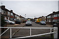
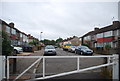
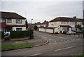
1
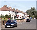
Aldridge Avenue, Enfield Lock
The houses seen here are just within the gridsquare since the boundary runs up the centre of the roadway. This part of Enfield was once a thriving manufacturing area and from the late nineteenth century until the mid-twentieth a considerable amount of terraced housing was constructed.
Image: © David Kemp
Taken: 11 Oct 2008
0.03 miles

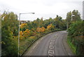
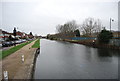
10
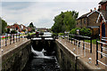
Enfield Lock
One of the locks encountered along the River Lea Navigation
Image: © Chris Heaton
Taken: 3 Sep 2017
0.10 miles