IMAGES TAKEN NEAR TO
Preston Gardens, ENFIELD, EN3 6EP
Introduction
This page details the photographs taken nearby to Preston Gardens, EN3 6EP by members of the Geograph project.
The Geograph project started in 2005 with the aim of publishing, organising and preserving representative images for every square kilometre of Great Britain, Ireland and the Isle of Man.

There are currently over 7.5m images from over14,400 individuals and you can help contribute to the project by visiting https://www.geograph.org.uk
Image Map
Images are licensed for reuse under creativecommons.org/licenses/by-sa/2.0
Notes
- Clicking on the map will re-center to the selected point.
- The higher the marker number, the further away the image location is from the centre of the postcode.
Image Listing (63 Images Found)
Images are licensed for reuse under creativecommons.org/licenses/by-sa/2.0
Image
Details
Distance
1
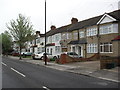
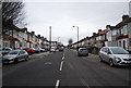
Newbury Avenue
1930s terraces in Enfield Lock.
Image: © Burgess Von Thunen
Taken: 3 May 2012
0.05 miles
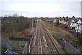
4
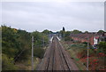
Approaching Enfield Lock station
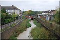
The railway line from Stratford to Broxbourne via Waltham Cross was opened by the Northern & Eastern Railway on 15th September 1840. Enfield Lock station was opened by the Eastern Counties Railway in 1855 as Ordnance Factory, and later renamed in 1886 to Enfield Lock. The lines through Enfield Lock were electrified on 5th May 1969.
Enfield Lock was the main station for the Royal Small Arms Factory until its closure in the late 1980s, and now serves the large housing development on the site known as Enfield Island Village, as well as the nearby Innova Science and Business Park.
This view is from the footbridge which carries the London LOOP over the line. The bridge a few yards ahead takes the Turkey Brook under the line. Enfield Lock station can be seen in the distance.
Image: © Marathon
Taken: 27 Sep 2017
0.05 miles
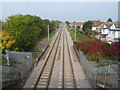
7
West Anglia / Lea Valley Line south of Enfield Lock
Image: © N Chadwick
Taken: 21 Oct 2012
0.07 miles
8
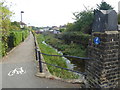
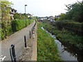
Turkey Brook alongside the London LOOP
Turkey Brook rises in Potters Bar. The brook flows in an easterly direction and is joined by other streams before merging with the River Lee Navigation below Enfield Lock. Here it has just passed under the railway line to the south of Enfield Lock station at the end of Bradley Road. The London LOOP follows the path ahead.
Image: © Marathon
Taken: 27 Sep 2017
0.08 miles
10
Turkey Brook alongside the London LOOP
Turkey Brook rises in Potters Bar. The brook flows in an easterly direction and is joined by other streams before merging with the River Lee Navigation below Enfield Lock. Here it has just passed under the railway line to the south of Enfield Lock station at the end of Bradley Road. The London LOOP follows the path ahead.
Image: © Marathon
Taken: 27 Sep 2017
0.08 miles