IMAGES TAKEN NEAR TO
Hertford Road, ENFIELD, EN3 5BN
Introduction
This page details the photographs taken nearby to Hertford Road, EN3 5BN by members of the Geograph project.
The Geograph project started in 2005 with the aim of publishing, organising and preserving representative images for every square kilometre of Great Britain, Ireland and the Isle of Man.

There are currently over 7.5m images from over14,400 individuals and you can help contribute to the project by visiting https://www.geograph.org.uk
Image Map
Images are licensed for reuse under creativecommons.org/licenses/by-sa/2.0
Notes
- Clicking on the map will re-center to the selected point.
- The higher the marker number, the further away the image location is from the centre of the postcode.
Image Listing (32 Images Found)
Images are licensed for reuse under creativecommons.org/licenses/by-sa/2.0
Image
Details
Distance
1
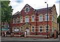
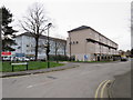
Enfield Highway Public Library
Carnegie Library of 1909, built to the designs of local district surveyor R. Collins. (Ref: The Buildings of England. London. 4: North (1998), p. 440)
Image: © Jim Osley
Taken: 30 Jul 2016
0.01 miles
3
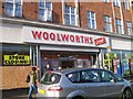
Woolworths Enfield Highway
Woolworths local on the Hertford Road. 7 days from closure, the store has recently been broken into hence the boarded up window.
Image: © Matthew Singh
Taken: 20 Dec 2008
0.04 miles
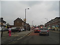
4
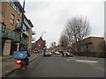
Hertford Road
The A1010, seen at the junction with Carterhatch Lane. On the left is a very recent shops and housing development whilst further back, beyond the junction with Cedar Avenue is a tyre fitters and a what appears to be a one-time public house now in use as an Indian grocers shop.
Image: © Martin Addison
Taken: 12 Feb 2011
0.05 miles
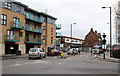
5
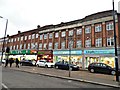
Shops on Hertford Road, Green Street, Enfield
Image: © David Howard
Taken: 12 Feb 2013
0.05 miles
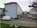
6
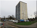
Block of flats near Enfield
A high-rise block of flats on Sherborne Avenue near Enfield, in the outer suburbs of north London.
Image: © Malc McDonald
Taken: 22 Feb 2020
0.06 miles
7
Hertford Road at the junction of Carterhatch Lane
Image: © David Howard
Taken: 12 Feb 2013
0.07 miles
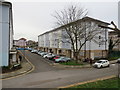
8
Lytchet Way Estate, near Enfield
The Lytchet Way housing estate near Enfield, in the outer suburbs of north London.
Image: © Malc McDonald
Taken: 22 Feb 2020
0.08 miles
9
Lytchet Way Estate, near Enfield
The Lytchet Way housing estate near Enfield, in the outer suburbs of north London.
Image: © Malc McDonald
Taken: 22 Feb 2020
0.09 miles
10
Lytchet Way Estate, near Enfield
The Lytchet Way housing estate near Enfield, in the outer suburbs of north London.
Image: © Malc McDonald
Taken: 22 Feb 2020
0.09 miles