IMAGES TAKEN NEAR TO
Napier Road, ENFIELD, EN3 4FH
Introduction
This page details the photographs taken nearby to Napier Road, EN3 4FH by members of the Geograph project.
The Geograph project started in 2005 with the aim of publishing, organising and preserving representative images for every square kilometre of Great Britain, Ireland and the Isle of Man.

There are currently over 7.5m images from over14,400 individuals and you can help contribute to the project by visiting https://www.geograph.org.uk
Image Map
Images are licensed for reuse under creativecommons.org/licenses/by-sa/2.0
Notes
- Clicking on the map will re-center to the selected point.
- The higher the marker number, the further away the image location is from the centre of the postcode.
Image Listing (37 Images Found)
Images are licensed for reuse under creativecommons.org/licenses/by-sa/2.0
Image
Details
Distance
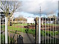
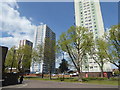
2
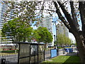
Tower blocks, Ponders End
Colour-coded blocks. The rightmost one is actually in TQ3695. Over the near fence are allotments.
Image: © Robin Webster
Taken: 11 Nov 2012
0.05 miles
3
Levels and Lines
Ponders End Station. The train stopped just here, and I thought this looked like a bit of a picture so I snapped it without even leaving my seat.
Slightly fuzzy due to railway glass, but not too bad.
Nigel Cox has done all the work and named the tower blocks, which are in the next square west, so here's his pic with info. Image
Image: © Des Blenkinsopp
Taken: 13 Sep 2012
0.05 miles
4
Tower blocks, Ponders End
A distant glimpse from Lincoln Road.
Image: © Robin Webster
Taken: 11 Nov 2012
0.06 miles
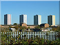
5
Tower blocks at Ponders End
These tower blocks totally dominate the area to the west of Ponders End station. This looks from Woodall Road across South Street.
Image: © Marathon
Taken: 19 Apr 2017
0.06 miles
6
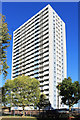
Merlin House, Ponders End
One of four large tower blocks on the Alma Road estate near Ponders End Station. They are colour coded, with different stripes on the side. This is Merlin, the blue one.
The one nearest the station has recently been demolished.
Image: © Des Blenkinsopp
Taken: 9 Oct 2018
0.07 miles
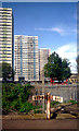
7
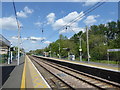
Ponders End station
The railway line from Stratford to Broxbourne via Waltham Cross was opened by the Northern & Eastern Railway on 15th September 1840. Ponders End station opened on the same day. The lines through Ponders End were electrified on 5th May 1969.
This is the view from the down platform. The next station in this direction is Brimsdown.
Image: © Marathon
Taken: 19 Apr 2017
0.07 miles
8
Alma Road
The A110 is carried over Alma Road, railway and canal on a raised viaduct.
Image: © John Reeves
Taken: 9 Jun 2012
0.07 miles
9
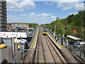
Ponders End station
The railway line from Stratford to Broxbourne via Waltham Cross was opened by the Northern & Eastern Railway on 15th September 1840. Ponders End station opened on the same day. The lines through Ponders End were electrified on 5th May 1969.
This is the view from the footbridge. A train bound for London Liverpool Street is just pulling in. The next station in this direction though is Brimsdown. On the left is one of the tower blocks which dominate the station - see http://www.geograph.org.uk/photo/5357726
Image: © Marathon
Taken: 19 Apr 2017
0.07 miles
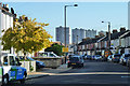
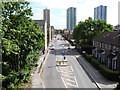
10
Tower blocks at Ponders End
These tower blocks totally dominate the area to the west of Ponders End station, although judging by a nearby poster Enfield Council has big plans for the area. This looks across South Street.
Image: © Marathon
Taken: 19 Apr 2017
0.07 miles