IMAGES TAKEN NEAR TO
Clay Hill, ENFIELD, EN2 9JA
Introduction
This page details the photographs taken nearby to Clay Hill, EN2 9JA by members of the Geograph project.
The Geograph project started in 2005 with the aim of publishing, organising and preserving representative images for every square kilometre of Great Britain, Ireland and the Isle of Man.

There are currently over 7.5m images from over14,400 individuals and you can help contribute to the project by visiting https://www.geograph.org.uk
Image Map
Images are licensed for reuse under creativecommons.org/licenses/by-sa/2.0
Notes
- Clicking on the map will re-center to the selected point.
- The higher the marker number, the further away the image location is from the centre of the postcode.
Image Listing (68 Images Found)
Images are licensed for reuse under creativecommons.org/licenses/by-sa/2.0
Image
Details
Distance
2
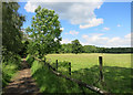
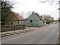
Field and Footpath
This looks like it's miles out in the country, but it's actually less than half a kilometre from suburban Enfield.
Image: © Des Blenkinsopp
Taken: 5 Jun 2014
0.10 miles
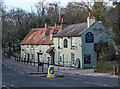
3
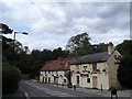
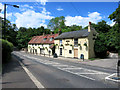
The Rose and Crown pub
The left hand side of the building is C17 timber-framed but faced with brick in C18. The right and side with the slate roof dates from C19. See http://www.britishlistedbuildings.co.uk/en-200602-the-rose-and-crown-public-house-greater-
Image: © Bikeboy
Taken: 16 Aug 2014
0.10 miles
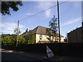
4
Clay Hill House Grounds
Seen from the footpath between Clay Hill and Hilly Fields Park. The house is currently a care home for elderly persons suffering from dementia.
Image: © Martin Addison
Taken: 26 Jul 2010
0.10 miles
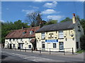
5
Rose & Crown, Clay Hill, near Enfield
The Rose & Crown pub on Clay Hill, on the northern fringe of Greater London near Enfield.
Image: © Malc McDonald
Taken: 22 Feb 2020
0.11 miles
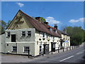
6
"Rose and Crown" public house, Clay Hill
Grade II listed - description at this https://historicengland.org.uk/listing/the-list/list-entry/1079555.
Image: © Jim Osley
Taken: 26 Nov 2017
0.11 miles
9
Rose & Crown (spot the difference)
Exactly the same picture as Christine Matthews' 2007 view Image
Or is it?
Playing "spot the difference" - The CR is back on Crown. The other door is blacked out. A different window is boarded up. They've lost the window boxes....etc.
More important, the pub was open and had a nice cool beer on a hot day walking the London Loop, which crosses the road just here.
Image: © Des Blenkinsopp
Taken: 5 Jun 2014
0.12 miles
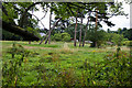
10
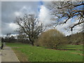
Hilly Fields Park
On the London Loop between Enfield Lock and Cockfosters, section 17 of the route. The London Loop (London Outer Orbital Path) is a 150-mile circular route and this section of it is 9.5 miles long. The London Loop is sometimes known as the M25 for walkers and it generally tends to follow parks, woodland and green open spaces.
Image: © Peter S
Taken: 29 Mar 2018
0.12 miles