IMAGES TAKEN NEAR TO
Auckland Close, ENFIELD, EN1 4PR
Introduction
This page details the photographs taken nearby to Auckland Close, EN1 4PR by members of the Geograph project.
The Geograph project started in 2005 with the aim of publishing, organising and preserving representative images for every square kilometre of Great Britain, Ireland and the Isle of Man.

There are currently over 7.5m images from over14,400 individuals and you can help contribute to the project by visiting https://www.geograph.org.uk
Image Map (98 Images)


Getting Data...Please wait
Leaflet Map data © OpenStreetMap
Images are licensed for reuse under creativecommons.org/licenses/by-sa/2.0
Notes
- Clicking on the map will re-center to the selected point.
- The higher the marker number, the further away the image location is from the centre of the postcode.
Image Listing (98 Images Found)
Images are licensed for reuse under creativecommons.org/licenses/by-sa/2.0
Image
Details
Distance
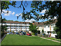
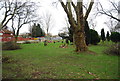
3
Green next to Dendridge Close
The Turkey Brook flows beyond the hedge and the London LOOP is just beyond that.
Image: © Marathon
Taken: 27 Sep 2017
0.04 miles
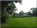
6
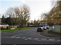
Dendridge Close, near Enfield
Dendridge Close is a cul-de-sac leading into a small housing estate in the outer suburbs of north London.
Image: © Malc McDonald
Taken: 1 Feb 2020
0.06 miles
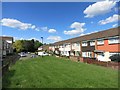
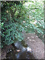
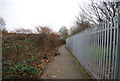
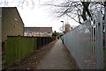
10
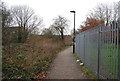
Footpath between Turkey Street and Auckland Close, EN1
The Turkey Brook runs to the right of the railings - see Image
Image: © Mike Quinn
Taken: 30 Jul 2014
0.07 miles