IMAGES TAKEN NEAR TO
Edenbridge Road, ENFIELD, EN1 2LL
Introduction
This page details the photographs taken nearby to Edenbridge Road, EN1 2LL by members of the Geograph project.
The Geograph project started in 2005 with the aim of publishing, organising and preserving representative images for every square kilometre of Great Britain, Ireland and the Isle of Man.

There are currently over 7.5m images from over14,400 individuals and you can help contribute to the project by visiting https://www.geograph.org.uk
Image Map
Images are licensed for reuse under creativecommons.org/licenses/by-sa/2.0
Notes
- Clicking on the map will re-center to the selected point.
- The higher the marker number, the further away the image location is from the centre of the postcode.
Image Listing (18 Images Found)
Images are licensed for reuse under creativecommons.org/licenses/by-sa/2.0
Image
Details
Distance
1
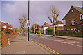
Park Avenue, Bush Hill Park, Enfield
Looking east down Park Avenue from the north-east corner of the junction with Wellington Road.
Image: © Christine Matthews
Taken: 20 Apr 2008
0.16 miles
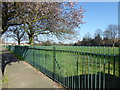
2
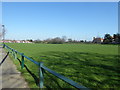
King George's Field
The nine acre site was purchased by Edmonton Borough Council with the help of a grant of £2,000 from King George's Fields Foundation, from which the playing field gets its name. The Foundation was set up in 1936 following the King's death in order to provide a living memorial to him through funding playing fields for young people.
As can be seen from the photograph it is rather featureless. This view is from Delhi Road, while Great Cambridge Road (the A10) is on the far side where the embankment and line of lamp posts can be seen.
Image: © Marathon
Taken: 15 Mar 2017
0.17 miles
4
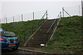
Steps from Dimsdale Drive to Great Cambridge Road
Image: © David Howard
Taken: 9 Mar 2020
0.18 miles
5
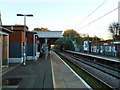
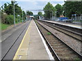
Bush Hill Park station
The only intermediate station on the short Enfield Town branch. On the platform towards Liverpool Street.
Image: © Robin Webster
Taken: 11 Nov 2012
0.18 miles
6
King George's Field
The nine acre site was purchased by Edmonton Borough Council with the help of a grant of £2,000 from King George's Fields Foundation, from which the playing field gets its name. The Foundation was set up in 1936 following the King's death in order to provide a living memorial to him through funding playing fields for young people.
As can be seen from the photograph it is rather featureless. This view is from Delhi Road, while Great Cambridge Road (the A10) is on the far side where the embankment and line of lamp posts can be seen just to the right of the tree.
Image: © Marathon
Taken: 15 Mar 2017
0.19 miles
7
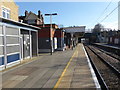
Bush Hill Park station
The line from Edmonton via Lower Edmonton to the centre of Enfield opened on 1st March 1849. At Lower Edmonton (now Edmonton Green) a single platform occupied a central position at the edge of the village green. At Enfield Town where the line terminated in the centre of Enfield, a three-storey, late 17th-century mansion, latterly a school attended by John Keats, was available to become the station house and offices. A little steam railmotor called 'Enfield appeared on the branch soon after its opening.
The first stage of a more direct line from Bethnal Green station to Stoke Newington station was opened by the Great Eastern Railway on 27th May 1872, and the route was continued on to Lower Edmonton on 22nd July 1872 and to Edmonton Junction on 1st August 1872. From 1st August 1872 trains ran on to Enfield Town via a new double line.
The 700 acre Bush Hill Park Park Estate west of the line and just south of the terminus was sold in 1872 to the Bush Hill Park Land Company for conversion to a villa colony for which a station was opened on 1st November 1880. In the following decade terraced housing appeared east of the new station with some 600 cottages existing by 1892. Bush Hill Park became one of those places where the railway formed a social boundary, with both classes using the same station, but not usually meting as they passed through at different times of the day.
On 31st May 2015 the station and all services that call here became part of the London Overground network.
This view from the up platform looks up the line towards the junction with the line down from Cheshunt. The next station in this direction is Edmonton Green.
Image: © Marathon
Taken: 15 Mar 2017
0.19 miles
9
Bush Hill Park railway station, Greater London
Opened in 1880 by the Great Eastern Railway on its line from London Liverpool Street via Edmonton to Enfield Town. View south east towards Edmonton and London.
Image: © Nigel Thompson
Taken: 30 May 2012
0.19 miles
10
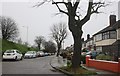
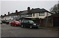
Pavement, Dryden Road, Bush Hill Park, Enfield
Looking up the pavement on the right hand side of Dryden Road in the direction of Bush Hill Park Station.
Image: © Christine Matthews
Taken: 20 Apr 2008
0.20 miles