IMAGES TAKEN NEAR TO
Manorway, ENFIELD, EN1 2JD
Introduction
This page details the photographs taken nearby to Manorway, EN1 2JD by members of the Geograph project.
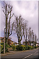
The Geograph project started in 2005 with the aim of publishing, organising and preserving representative images for every square kilometre of Great Britain, Ireland and the Isle of Man.

There are currently over 7.5m images from over14,400 individuals and you can help contribute to the project by visiting https://www.geograph.org.uk
Image Map
Images are licensed for reuse under creativecommons.org/licenses/by-sa/2.0
Notes
- Clicking on the map will re-center to the selected point.
- The higher the marker number, the further away the image location is from the centre of the postcode.
Image Listing (11 Images Found)
Images are licensed for reuse under creativecommons.org/licenses/by-sa/2.0
Image
Details
Distance
1
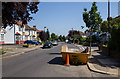
Queen Anne's Grove
Looking NNE along Queen Anne's Grove towards the junction with Manorway.
The building skip in the foreground is indicative of a fair amount of general improvement and renovation works that appeared to be going on in the general area.
Image: © David P Howard
Taken: 24 Jul 2014
0.20 miles
2
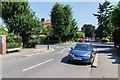
Queen Anne's Grove
View NNE past the junction with Manorway.
Image: © David P Howard
Taken: 24 Jul 2014
0.20 miles
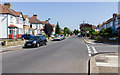
4
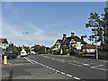
Park Avenue, Bush Hill Park, Enfield
Looking east down Park Avenue from the north-east corner of the junction with Wellington Road.
Image: © Christine Matthews
Taken: 20 Apr 2008
0.22 miles
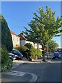
5
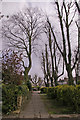
Trees, Wellington Road, Bush Hill Park, Enfield
Street trees and planting in Wellington Road looking towards the junction with Park Avenue.
Image: © Christine Matthews
Taken: 20 Apr 2008
0.22 miles
6
Stag and Hounds public house
The Stag and Hounds public house in Bury Street West near the junction with Little Bury Street which you can see on the left hand side of this photograph. We are looking west.
Image: © Christine Matthews
Taken: 12 Sep 2005
0.23 miles
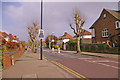
7
Pavement, Wellington Road, Bush Hill Park, Enfield
Looking towards Park Avenue along pavement on the north side of Wellington Road.
Image: © Christine Matthews
Taken: 20 Apr 2008
0.23 miles
8
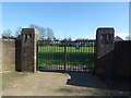
Former entrance to King George's Field
The nine acre site was purchased by Edmonton Borough Council with the help of a grant of £2,000 from King George's Fields Foundation, from which the playing field gets its name. The Foundation was set up in 1936 following the King's death in order to provide a living memorial to him through funding playing fields for young people.
It is rather featureless. This view is from Delhi Road looking through what must have been the formal entrance, although this is now firmly padlocked. In any case the main playing field can be accessed further along Delhi Road over a low fence - see http://www.geograph.org.uk/photo/5314066
Image: © Marathon
Taken: 15 Mar 2017
0.23 miles
9
Queen Anne's Grove
View NNE from Queen Anne's Grove, across Park Avenue, towards Queen Anne's Gardens.
Image: © David P Howard
Taken: 24 Jul 2014
0.24 miles
10
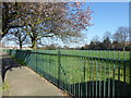
King George's Field
The nine acre site was purchased by Edmonton Borough Council with the help of a grant of £2,000 from King George's Fields Foundation, from which the playing field gets its name. The Foundation was set up in 1936 following the King's death in order to provide a living memorial to him through funding playing fields for young people.
As can be seen from the photograph it is rather featureless. This view is from Delhi Road, while Great Cambridge Road (the A10) is on the far side where the embankment and line of lamp posts can be seen just to the right of the tree.
Image: © Marathon
Taken: 15 Mar 2017
0.24 miles