IMAGES TAKEN NEAR TO
Clydesdale Walk, BROXBOURNE, EN10 6BP
Introduction
This page details the photographs taken nearby to Clydesdale Walk, EN10 6BP by members of the Geograph project.
The Geograph project started in 2005 with the aim of publishing, organising and preserving representative images for every square kilometre of Great Britain, Ireland and the Isle of Man.

There are currently over 7.5m images from over14,400 individuals and you can help contribute to the project by visiting https://www.geograph.org.uk
Image Map
Images are licensed for reuse under creativecommons.org/licenses/by-sa/2.0
Notes
- Clicking on the map will re-center to the selected point.
- The higher the marker number, the further away the image location is from the centre of the postcode.
Image Listing (19 Images Found)
Images are licensed for reuse under creativecommons.org/licenses/by-sa/2.0
Image
Details
Distance
2
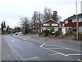
Simpsons of Turnford
Simpsons of Turnford is a fishing tackle shop (green signage on building).
Unusual in that it is in a residential area, rather than your normal shopping area..
Image: © Talisman
Taken: 18 Jan 2009
0.12 miles
3
Knock knock!
You have to try and create some humour in the photos
Image: © David Howard
Taken: 20 Apr 2019
0.13 miles
4
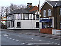
Turnford Massey Pub, now Cumin Indian Restaurant
The restaurant was the Turnford Massey Pub until about 18 months ago.
The exterior suggests a very much older structure than it actually is. Built sometime in the 1800s and known as the Old Bull's Head.
Strangely it is across the road from the Bull's Head Pub, which the sign says "since 1525" - so which one is the oldest !
Next to Cumin Restaurant is the Turnford Stores
Image: © Talisman
Taken: 18 Jan 2009
0.13 miles
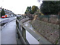
5
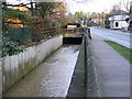
Turnford Brook
Looking north along High Road Turnford
Turnford brook coming out of a culvert under the Bulls Head.
On the right is the former Old Bulls Head pub and Image
Image: © Talisman
Taken: 18 Jan 2009
0.15 miles
6
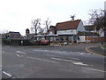
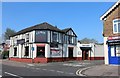
Bulls Head Pub, Turnford
View of the Bulls Head Pub, High Road Turnford from Image which was previously the "Old Bulls Head".
The Bulls Head sign states "since 1525"
Image: © Talisman
Taken: 24 Jan 2009
0.17 miles
7
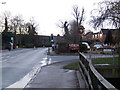
High Road Turnford
Looking south along High Road Turnford by the sign for the Bulls Head Pub (which is just off to the right).
Turnford Brook is in the bottom right corner, where it goes under Rochford Close and the Bulls Head Car Park.
Image: © Talisman
Taken: 18 Jan 2009
0.17 miles
8
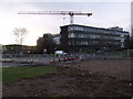
Turnford College building site
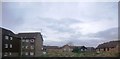
Seen here to the rear of the main building is some of the building work that is going on Hertford Regional College, Turnford.
The expansion was partly funded by selling off a lot of the grounds to build houses and flats (off to the left of the picture).
Image: © Talisman
Taken: 18 Jan 2009
0.17 miles
9
Turnford Brook and High Road Turnford
Looking south along High Road Turnford.
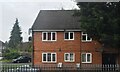
On the left are Turnford Villas, which are some of the houses built for the workers at the Rochford Nurseries that covered most of this area.
On the right is Turnford Brook.
Image: © Talisman
Taken: 18 Jan 2009
0.17 miles