
IMAGES TAKEN NEAR TO
McBeath Avenue, EH55 8FZ
Introduction
This page details the photographs taken nearby to McBeath Avenue, EH55 8FZ by members of the Geograph project.
The Geograph project started in 2005 with the aim of publishing, organising and preserving representative images for every square kilometre of Great Britain, Ireland and the Isle of Man.

There are currently over 7.5m images from over14,400 individuals and you can help contribute to the project by visiting https://www.geograph.org.uk
Image Map
Images are licensed for reuse under creativecommons.org/licenses/by-sa/2.0
Notes
- Clicking on the map will re-center to the selected point.
- The higher the marker number, the further away the image location is from the centre of the postcode.
Image Listing (13 Images Found)
Images are licensed for reuse under creativecommons.org/licenses/by-sa/2.0
Image
Details
Distance
1

Polbeth and the A71
Seen from the air after leaving Edinburgh Airport. West Calder High School is to the left, and running across the upper half of the image is the Edinburgh-Glasgow Central rail line.
Image: © M J Richardson
Taken: 9 Oct 2012
0.09 miles
2

Site of Recently Demolished High School
The rubble marks the site of the original West Calder High School, demolished just a year or so ago. The replacement opened at the start of the 2018 school year, and can just about get away with its name, being situated in the brief bit of no-man's-land between West Calder and Polbeth. This site is actually situated East of the village of Polbeth which itself is situated East of the village of West Calder.
I initially thought the posts on the right of the picture were floodlights from the all-weather football pitch, but since there are five of them it's more likely they were just lampposts which were situated around the grounds. I'm surprised that the area hasn't been put back to grass, as it is a rather desolate place now, but it is quite possible the land is earmarked for future development.
Image: © Ian Dodds
Taken: 25 Mar 2021
0.10 miles
3
Stone, Limefield Recreation Park
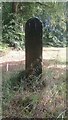
This stone is just under four feet high, and has a cross-section measuring a foot by eight inches. There is no mention of it anywhere online, nor does it appear on any maps, anywhere, from any era. Although the light wasn't in my favour for the picture, what looks like a man-made dimpled pattern can be made out towards the bottom of the stone. The opposite side hasn't been worked, but contains a few curious deep cut-lines towards the bottom. It does look like it was designed to be ornamental, and it could of course have been moved here from somewhere else relatively recently. There are no holes indicating it has ever been used as a gatepost.
Limefield Recreation Park is shown on some modern maps as encompassing both the far larger recreational ground (which includes football pitches) on the other side of Harwood Water, as well as the small grassy area to the right of this stone. As far as I'm concerned, however, it should only be the small area beyond the stone, on the way to Polbeth Bowling Club, that takes the name.
Until recently there were a couple of tennis courts on the way to the bowling club, but these have now gone, providing a car park for the bowling club which is unlikely to ever reach capacity. The area of grass between the stone and the large parking area is marked on a 1960s OS map as a putting green and, whilst there is no indication of what its purpose was, the whole area of land which today contains the large lawn, car park and bowling club, is shown as being fenced or walled-off from the surrounding woodland on an 1890s OS map.
Image: © Ian Dodds
Taken: 20 Aug 2022
0.11 miles
4

Path under Railway Bridge in Heavy Rain
As is usually the case, underpass has been here since railway was built about 150 years ago. Hollow left from old quarry works can be found on right just after the bridge.
Image: © Ian Dodds
Taken: 28 Jun 2020
0.13 miles
5

Limefield Falls, Polbeth
This interesting waterfall is situated on Harwood Water, a tributary of the River Almond, at the far side of the large recreation park in Polbeth. The picture was taken from a viewing platform which was only completed a few months back, along with the fish pass that can be seen on the right of the shot.
A number of fish passes (also often called fishways or fish ladders) have been constructed in West Lothian over the last few years. They are put in to allow fish to travel upstream when they wouldn't otherwise be able to because of an obstruction, which is usually a weir, as is the case here. Although not always mentioned they do often assist fish travelling downstream too of course - I don't imagine many fish relish the prospect of dropping eight feet from the edge here! This fish pass has to double back on itself so as not to be impassably steep, but it still looks like quite a challenge to me. Like most things, these fish passes are quite technical affairs when you investigate them in more detail, and there is no doubt a lot going on that is hidden from view - the water flow down the way has to be managed carefully and resting pools are usually needed for the fish along the passes, for instance.
The falls, which were once a few feet higher, are man-made, and purely decorative (a lade was added later as a bit of an afterthought, to provide water for a walled garden). They were put in in 1880 by James 'Paraffin' Young as a tribute to the famous missionary and explorer David Livingstone. Young, the pioneer of West Lothian's historically important shale oil industry, lived at the nearby Limefield House and was a friend of Livingstone from the days before they had both made their mark -in fact it could be said that Young actually helped Livingstone make his mark, as he sponsored a number of his African trips.
Livingstone is reckoned to have been the first European to view the Victoria Falls, on the Zambezi River, between Zambia and Zimbabwe, and it was he who gave it its name - it obviously has a far more exotic real name in a local language, but for whatever reason Livingstone felt duty bound to honour his queen! Considering the Victoria Falls is 350 feet high there isn't much of a comparison really, but it's a nice spot and a good story!
Image: © Ian Dodds
Taken: 31 May 2021
0.13 miles


8
Livingston from the air
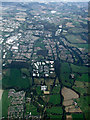
Polbeth is in the foreground, with Brucefiled Industrial Estate also prominent in the foreground.
Image: © Thomas Nugent
Taken: 22 Sep 2014
0.19 miles
9

West Calder High School
Opened in 1965 and now with a roll of 900 pupils, serving all the Calders area. There is a proposal to relocate the school to an open area at Parkhead in NT0263 http://www.westlothian.gov.uk/west-calder-high-consultation.
Image: © M J Richardson
Taken: 29 Jul 2015
0.19 miles
10

Old School Playing Fields Notice
The remarkably thing about this notice isn't that it escaped the demolition work when the original West Calder High School was pulled down a year or two ago, but that it was still there when it got pulled down. I'd guess it was erected when the original school was built in 1965. It definitely dates from before 1975 though, as that year council boundaries were redrawn all over Scotland - as can just about be seen from the blurry text this used to be Midlothian. In fact East, West and Mid Calder were all originally part of Midlothian.
It is interesting to note, from looking at the second rule on the list, that it was a given that it would be a headmaster rather than a headmistress in charge!
Image: © Ian Dodds
Taken: 25 Mar 2021
0.19 miles