
Stone, Limefield Recreation Park
Introduction
The photograph on this page of Stone, Limefield Recreation Park by Ian Dodds as part of the Geograph project.
The Geograph project started in 2005 with the aim of publishing, organising and preserving representative images for every square kilometre of Great Britain, Ireland and the Isle of Man.

There are currently over 7.5m images from over 14,400 individuals and you can help contribute to the project by visiting https://www.geograph.org.uk
Stone, Limefield Recreation Park
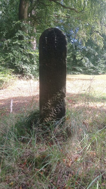
Image: © Ian Dodds Taken: 20 Aug 2022
This stone is just under four feet high, and has a cross-section measuring a foot by eight inches. There is no mention of it anywhere online, nor does it appear on any maps, anywhere, from any era. Although the light wasn't in my favour for the picture, what looks like a man-made dimpled pattern can be made out towards the bottom of the stone. The opposite side hasn't been worked, but contains a few curious deep cut-lines towards the bottom. It does look like it was designed to be ornamental, and it could of course have been moved here from somewhere else relatively recently. There are no holes indicating it has ever been used as a gatepost. Limefield Recreation Park is shown on some modern maps as encompassing both the far larger recreational ground (which includes football pitches) on the other side of Harwood Water, as well as the small grassy area to the right of this stone. As far as I'm concerned, however, it should only be the small area beyond the stone, on the way to Polbeth Bowling Club, that takes the name. Until recently there were a couple of tennis courts on the way to the bowling club, but these have now gone, providing a car park for the bowling club which is unlikely to ever reach capacity. The area of grass between the stone and the large parking area is marked on a 1960s OS map as a putting green and, whilst there is no indication of what its purpose was, the whole area of land which today contains the large lawn, car park and bowling club, is shown as being fenced or walled-off from the surrounding woodland on an 1890s OS map.
Images are licensed for reuse under creativecommons.org/licenses/by-sa/2.0
Image Location

Latitude
55.860715
Longitude
-3.546204