IMAGES TAKEN NEAR TO
Drumshoreland Place, LIVINGSTON, EH53 0PE
Introduction
This page details the photographs taken nearby to Drumshoreland Place, EH53 0PE by members of the Geograph project.
The Geograph project started in 2005 with the aim of publishing, organising and preserving representative images for every square kilometre of Great Britain, Ireland and the Isle of Man.

There are currently over 7.5m images from over14,400 individuals and you can help contribute to the project by visiting https://www.geograph.org.uk
Image Map
Images are licensed for reuse under creativecommons.org/licenses/by-sa/2.0
Notes
- Clicking on the map will re-center to the selected point.
- The higher the marker number, the further away the image location is from the centre of the postcode.
Image Listing (10 Images Found)
Images are licensed for reuse under creativecommons.org/licenses/by-sa/2.0
Image
Details
Distance
1

Pumpherston.
Oil mining village, predating Livingston New Town. Now on the eastern edge of the new metropolis. A typical Scottish November day.
Image: © Richard Webb
Taken: 8 Nov 2005
0.12 miles
2
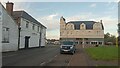
Old Co-op Buildings, Pumpherston
If somebody from a hundred years ago was transported forward in time to today, they would quickly conclude that the only things people aren't willing to use the cars they now all have to drive for are haircuts and takeaways. Pumpherston has never been that heavy on hairdressers, but until recently was something of a phenomenon in takeaway density - a relatively small village, it once boasted seven, including 3 Chinese. I only spotted three or four open tonight; the rest were shuttered.
The big building ahead was once the village's main Co-op. This seems to have been more of an early shopping complex than the Co-ops we are familiar with today. It once housed a butchers, a drapers (in the olden days people made a lot of their clothes themselves, or at least paid somebody else to do so for them), a furniture store, a grocers and a general store. The building on the left, now divided between umpteen businesses, was built in the 1920s and was the Co-op bakery.
The Co-op, which was part of the West Calder Co-operative Society at the time, arrived here in the 1880s. They took over an existing store and upgraded and expanded it. Within 20 years, however, they demolished it all and built the building shown here, complete with the clock tower which now only tells the right time in the winter. The ScottishShale website has a lot of pictures of it (including a colour postcard), but even they have no idea of the purpose of the bell above the clock.
The old shop closed in the early 1980s. I'm not sure when the new Co-op opened, but it occupies a building which was formerly an independent store and can be seen in the distance, opposite the unseen side of the old building.
Image: © Ian Dodds
Taken: 27 Aug 2022
0.12 miles
3
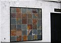
Oilshale.
Wall plaque on a pub made of the shale that was West Lothian's fortune. The rock here is rich in oil, and before the big North American oilwells started full production, this was a major source of oil. Then it was wanted mainly for lamps and cooking fuel. Having to be mined prior to extraction, it was soon uneconomic and the industry declined.
The legacy can be seen in many places, huge bings of cooked shale, dumped after the oil was boiled off.
Image: © Richard Webb
Taken: 8 Nov 2005
0.13 miles
4

Eyesores don't just happen
Another advert goes up in our space. Pumpherston, West Lothian.
Image: © Richard Webb
Taken: 8 Nov 2005
0.13 miles
5

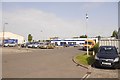
Kelvin Square, Pumpherston
Part of Livingston's Houston Industrial Estate.
Image: © Richard Webb
Taken: 16 May 2011
0.13 miles
6
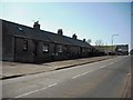
Miners' Row Pumpherston
Cottages on Drumshoreland Road.
Image: © Jim Smillie
Taken: 2 Apr 2009
0.14 miles
7
Kelvin Square
Industrial units, Pumpherston.
Image: © Richard Webb
Taken: 9 Jun 2018
0.14 miles
8
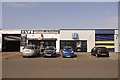
Kelvin Square
Industrial estate, Pumpherston. There are two tyre outlets here, useful when you have just had a flat on the M8.
Image: © Richard Webb
Taken: 9 Jun 2018
0.15 miles
9
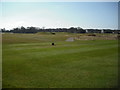
Pumpherston Golf Course
View over 16th tee.
Image: © Jim Smillie
Taken: 2 Apr 2009
0.22 miles
10
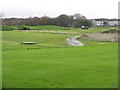
Pumpherston Golf Course
Very wet after much rain.
Image: © M J Richardson
Taken: 26 Nov 2009
0.24 miles