IMAGES TAKEN NEAR TO
Crosshill Drive, BO'NESS, EH51 9JB
Introduction
This page details the photographs taken nearby to Crosshill Drive, EH51 9JB by members of the Geograph project.
The Geograph project started in 2005 with the aim of publishing, organising and preserving representative images for every square kilometre of Great Britain, Ireland and the Isle of Man.

There are currently over 7.5m images from over14,400 individuals and you can help contribute to the project by visiting https://www.geograph.org.uk
Image Map
Images are licensed for reuse under creativecommons.org/licenses/by-sa/2.0
Notes
- Clicking on the map will re-center to the selected point.
- The higher the marker number, the further away the image location is from the centre of the postcode.
Image Listing (17 Images Found)
Images are licensed for reuse under creativecommons.org/licenses/by-sa/2.0
Image
Details
Distance
1
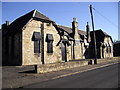
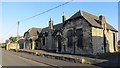
The Barony Theatre, Borrowstoun Rd, Borrowstoun
Image: © John Lord
Taken: 19 Sep 2012
0.06 miles
2
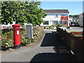
Housing estate at Borrowstoun
With decoration for the local gala day.
Image: © M J Richardson
Taken: 24 Jun 2018
0.06 miles
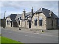
3
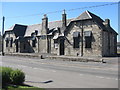
The Barony Theatre at Borrowstoun
The home of the Barony Players since 1966, with 125 seats https://www.baronyplayers.co.uk/. Originally the building was Borrowstoun Primary School.
Image: © M J Richardson
Taken: 24 Jun 2018
0.06 miles
4
The Barony Theatre at Borrowstoun
The home of the Barony Players since 1966, with 125 seats https://www.baronyplayers.co.uk/. Originally the building was Borrowstoun Primary School.
Image: © M J Richardson
Taken: 24 Jun 2018
0.06 miles
5
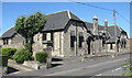
The Barony Theatre
For nearly 50 years there has been a theatre in this former primary school.
Image: © Richard Webb
Taken: 25 Aug 2014
0.07 miles
6
Barony Theatre
The local amateur dramatic society and film society use this former school building which has been converted into a theatre with appropriate seating and a stage. There is room for storage of props and costumes.
Image: © Tom Sargent
Taken: 26 Aug 2007
0.08 miles
7
Derelict Factory
This site once held a clothing factory providing shirts, track suits and athletic kit for large stores. The work could be don cheaper abroad and the factory closed.
Image: © Tom Sargent
Taken: 26 Aug 2007
0.08 miles
8
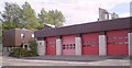
Fire Station
Strictly speaking Bo’ness is not big enough for a full station but being right next to the petrochemical complex at Grangemouth means increased risk.
Image: © Tom Sargent
Taken: 26 Aug 2007
0.10 miles
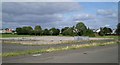
9
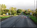
Linlithgow Road, Borrowstoun
Looking down yet another closed road towards Bo'ness along the A706. At this time there were many road closures, often in cases where a few years earlier there would have been lights or a stop/go board. Many of my journeys are affected/thwarted. This road was closed for several weeks.
Image: © Richard Webb
Taken: 20 Sep 2011
0.11 miles
10
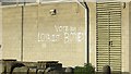
"Political" graffiti, Bo'ness
During the referendum campaign in 2014, the Orange Order said that they would leave if the pro-independence side won. Mmm, tempting.
Image: © Richard Webb
Taken: 25 Aug 2014
0.12 miles