IMAGES TAKEN NEAR TO
Craiglockhart Park, EDINBURGH, EH14 1EX
Introduction
This page details the photographs taken nearby to Craiglockhart Park, EH14 1EX by members of the Geograph project.
The Geograph project started in 2005 with the aim of publishing, organising and preserving representative images for every square kilometre of Great Britain, Ireland and the Isle of Man.

There are currently over 7.5m images from over14,400 individuals and you can help contribute to the project by visiting https://www.geograph.org.uk
Image Map
Images are licensed for reuse under creativecommons.org/licenses/by-sa/2.0
Notes
- Clicking on the map will re-center to the selected point.
- The higher the marker number, the further away the image location is from the centre of the postcode.
Image Listing (73 Images Found)
Images are licensed for reuse under creativecommons.org/licenses/by-sa/2.0
Image
Details
Distance
2
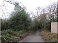
Path into Slateford Dell
Off Craiglockhart Road South and leading to the Water of Leith through Colinton Dell and Slateford Dell.
Image: © Richard Webb
Taken: 4 Jan 2014
0.04 miles
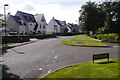
4
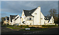
Redhall House Avenue
Part of a small development of new and still rather raw-looking upmarket houses in the grounds of Redhall Estate.
Image: © Anne Burgess
Taken: 20 Nov 2011
0.07 miles
6
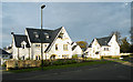
Redhall House Drive
Part of a small development of new and still rather raw-looking upmarket houses in the grounds of Redhall Estate.
Image: © Anne Burgess
Taken: 20 Nov 2011
0.09 miles
7
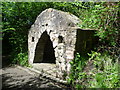
Craiglockhart Dell east grotto
One of two rustic grottos built c.1756 on the former grounds of Craiglockhart House.
Image: © kim traynor
Taken: 22 May 2013
0.09 miles
8
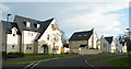
Redhall House Avenue
Part of a small development of new and still rather raw-looking upmarket houses in the grounds of Redhall Estate.
Image: © Anne Burgess
Taken: 20 Nov 2011
0.09 miles
9
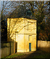
Redhall Doocot
The doocot is of an unusual hexagonal plan, and contained 757 nestboxes. A small plaque on the post near the door says that it was built in 1756 by John Christy for Inglis of Redhall. On the back is a panel with the arms of Sir Adam Otterburn, who died in 1548.
Image: © Anne Burgess
Taken: 20 Nov 2011
0.10 miles
10
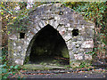
West Grotto
This is one of two grottos built for Dr Alexander Munro of Craiglockhart in about 1830, when such buildings were very fashionable. They were intended to provide shelter for ladies strolling in the gardens. The interriors are decorated with sea shells.
Image: © Anne Burgess
Taken: 20 Nov 2011
0.11 miles