IMAGES TAKEN NEAR TO
Moorfields Highwalk, LONDON, EC2Y 9DP
Introduction
This page details the photographs taken nearby to Moorfields Highwalk, EC2Y 9DP by members of the Geograph project.
The Geograph project started in 2005 with the aim of publishing, organising and preserving representative images for every square kilometre of Great Britain, Ireland and the Isle of Man.

There are currently over 7.5m images from over14,400 individuals and you can help contribute to the project by visiting https://www.geograph.org.uk
Image Map
Images are licensed for reuse under creativecommons.org/licenses/by-sa/2.0
Notes
- Clicking on the map will re-center to the selected point.
- The higher the marker number, the further away the image location is from the centre of the postcode.
Image Listing (1737 Images Found)
Images are licensed for reuse under creativecommons.org/licenses/by-sa/2.0
Image
Details
Distance
1
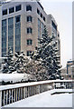
Moorfields Highwalk, London EC2 in the snow
Another part of the Moorfields Highwalk taken in the heavy snow of February 1991. With the fir trees it looks like Christmas!
Image: © Christine Matthews
Taken: Unknown
0.00 miles
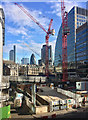
2
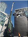
Cladding going up on new building on Moor Lane
This new building is part of the new development between Moor Lane and Moorgate.
Image: © Martyn Pattison
Taken: 10 Aug 2022
0.01 miles
3
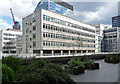
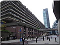
11 Moorfields Highwalk
An office block dating probably from the 1960s with bands of abstract shapes carved below the windows. It appears to be empty and may, like much else built in that most tainted of decades, be due for demolition.
To its right is a bit of a telephone exchange (Image]) and, beyond, a bit of City Tower (Image]).
The shot is taken from one of the walkways on the Barbican Estate.
Image: © Stephen Richards
Taken: 14 May 2011
0.01 miles
4
Development, Moor Lane (3)
For the new Liverpool Street Elizabeth Line (aka Crossrail) station, about four years on from Image
These upper stages will probably offer shops or offices or a lifestyle. Or something.
The defunct walkway has been adorned with lots of pot plants.
Image: © Stephen Richards
Taken: 13 Feb 2021
0.01 miles
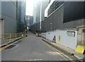
5
Development, Moor Lane (1)
This building Image] has gone in the cause of a western entrance to the new Liverpool Street Crossrail station, and the usual shops and offices will spring up (101 Moorgate).
Demolition has opened up a view of many of the City's shiny new toys.
Image: © Stephen Richards
Taken: 13 Mar 2017
0.01 miles
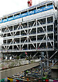
6

Development, Moor Lane (2)
This building Image] has gone in the cause of a western entrance to the new Liverpool Street Crossrail station, and the usual shops and offices will spring up (101 Moorgate). The highwalk now goes nowhere - will it be reinstated?
The big block behind is Image
Image: © Stephen Richards
Taken: 13 Mar 2017
0.01 miles
7
The City: Magnus Magnusson time (53)
Looking from Moor Lane into New Union Street [West out of Moorfields, at No.21, to Moor Lane (P.O. Directory). In Cripplegate Ward Without. First mention : O.S. 1848-51. Seems to occupy the site of Gun Alley (q.v.), Sugar loaf Alley and Court in the earlier maps. in Henry A Harben, 'New Street Hill - Newchurch', in A Dictionary of London (London, 1918)]
Image: © Basher Eyre
Taken: 23 Sep 2023
0.01 miles
8
The Square Mile in one day (winter 142)
Image: © Basher Eyre
Taken: 20 Nov 2016
0.02 miles
9

Moorfields Highwalk, London EC2 in the snow
A rare scene to see this amount of snow in Central London. This snowfall was in February 1991.
Image: © Christine Matthews
Taken: Unknown
0.02 miles
10
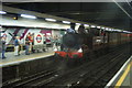
View of Met 1 pulling into Moorgate station #2
Today and next Saturday 9th August, a special steam train (the Met 1 locomotive, an original London Underground engine restored recently to its former glory) ran on the Hammersmith & City line to celebrate the 150th anniversary of the line. This was the last train of the day, arriving at Moorgate at 15:55 and departing for Northfields on the Piccadilly line at 16:25. Looking north-northwest from the island platform between the sidings and the westbound Hammersmith & City, Circle and Metropolitan line platform.
Image: © Robert Lamb
Taken: 2 Aug 2014
0.02 miles