IMAGES TAKEN NEAR TO
Leabank Square, LONDON, E9 5LR
Introduction
This page details the photographs taken nearby to Leabank Square, E9 5LR by members of the Geograph project.
The Geograph project started in 2005 with the aim of publishing, organising and preserving representative images for every square kilometre of Great Britain, Ireland and the Isle of Man.

There are currently over 7.5m images from over14,400 individuals and you can help contribute to the project by visiting https://www.geograph.org.uk
Image Map
Images are licensed for reuse under creativecommons.org/licenses/by-sa/2.0
Notes
- Clicking on the map will re-center to the selected point.
- The higher the marker number, the further away the image location is from the centre of the postcode.
Image Listing (480 Images Found)
Images are licensed for reuse under creativecommons.org/licenses/by-sa/2.0
Image
Details
Distance
1

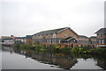
View of the Gherkin and the Cheese Grater and towerblocks in Bow from Queen Elizabeth Olympic Park
Looking west-southwest. The towerblocks from left to right are: Sandall House on Hewlett Road, Ingram House on Old Ford Road, Clare House in Hawthorn Avenue, Elton House on Candy Street and Waverton House on Ollerton Close.
Image: © Robert Lamb
Taken: 22 Jun 2014
0.01 miles
3
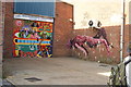
View of street art on the shutter and wall of Central Magazine Deliveries and Book Returns
Looking north-northwest.
Image: © Robert Lamb
Taken: 4 Jul 2015
0.04 miles
4
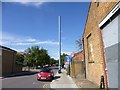
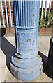
Hackney Wick, stenchpipe
On Berkshire Road. For detail of the maker's name, see Image
Image: © Mike Faherty
Taken: 8 Sep 2012
0.04 miles
5

View of street art on a shutter on Wallis Road
Looking north-northwest.
Image: © Robert Lamb
Taken: 4 Jul 2015
0.04 miles
6
View of "I Heart You" on the side wall of a garage on Wallis Road from Berkshire Road
Looking north-northeast.
Image: © Robert Lamb
Taken: 4 Jul 2015
0.05 miles
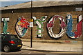
7
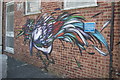
View of a colourful bird on a wall in Wallis Road
Looking north-northwest.
Image: © Robert Lamb
Taken: 4 Jul 2015
0.05 miles
10
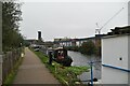
Lee Navigation: old concrete footbridge
I do not know what the original purpose of this unattractive structure was: it is totally enclosed and is now out of use, presumably awaiting demolition. I can only surmise that it may have been used by pupils at the school (left) to access sports fields on the eastern side of the cut. The school itself is a large and attractive building, but surrounding buildings prevent an effective photograph of it.
Image: © Dr Neil Clifton
Taken: 18 Sep 2008
0.05 miles