IMAGES TAKEN NEAR TO
Bourne Road, LONDON, E7 9EU
Introduction
This page details the photographs taken nearby to Bourne Road, E7 9EU by members of the Geograph project.
The Geograph project started in 2005 with the aim of publishing, organising and preserving representative images for every square kilometre of Great Britain, Ireland and the Isle of Man.

There are currently over 7.5m images from over14,400 individuals and you can help contribute to the project by visiting https://www.geograph.org.uk
Image Map
Images are licensed for reuse under creativecommons.org/licenses/by-sa/2.0
Notes
- Clicking on the map will re-center to the selected point.
- The higher the marker number, the further away the image location is from the centre of the postcode.
Image Listing (21 Images Found)
Images are licensed for reuse under creativecommons.org/licenses/by-sa/2.0
Image
Details
Distance
1
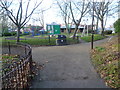
Entrance to Cann Hall Park
This tiny park is seen here from the entrance in Cann Hall Road. Despite its small size the park has a five-a-side kickabout area, a floodlit skate park, a pavilion, a sensory garden, an under 12's play area and an under 7's play area.
Image: © Marathon
Taken: 14 Jan 2015
0.05 miles
2
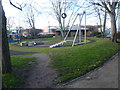
Cann Hall Park
This tiny park is seen here from near the entrance in Cann Hall Road. Despite its small size the park has a five-a-side kickabout area, a floodlit skate park, a pavilion, a sensory garden, an under 12's play area and an under 7's play area.
Image: © Marathon
Taken: 14 Jan 2015
0.05 miles
3
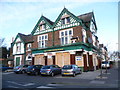
The closed Lord Rookwood
The Lord Rookwood is on the corner of Cann Hall Road and Cobbold Road. The trees of Wanstead Flats can be seen on the right in the distance.
Image: © Marathon
Taken: 14 Jan 2015
0.08 miles
5
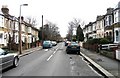
Woodhouse Road, Leytonstone, London E11
Image: © John Salmon
Taken: 25 Feb 2007
0.14 miles
6
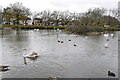
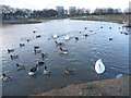
Jubilee Pond, Wanstead Flats
Looking across the pond towards Dames Road. The pond was busy with lots of gulls, geese, ducks and swans - including many juveniles.
Image: © Trevor Harris
Taken: 12 Dec 2020
0.15 miles
7
Jubilee Pond
Was originally known as "Model Yacht Pond", but got its new name to mark the Golden Jubilee of Queen Elizabeth II, when renovated in 2002.
Image: © Roger Jones
Taken: 27 Jul 2011
0.16 miles
8
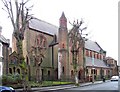
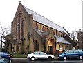
St Margaret & St Columba, Leytonstone, London E11
Image: © John Salmon
Taken: 25 Feb 2007
0.16 miles
9
St Margaret & St Columba, Leytonstone, London E11
Image: © John Salmon
Taken: 25 Feb 2007
0.17 miles
10
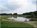
Jubilee Pond, Wanstead Flats
Wanstead Flats form the southernmost portion of Epping Forest. A perambulation of 1225 defined the southern boundary of Epping Forest as the main road from Bow Bridge via Stratford to Romford. The woodland extended south at least as far as Plashet at the time of the Domesday Book of 1086 (Plashet was a Norman-French name meaning a type of forest enclosure). Most of the woodland on what is now Wanstead Flats disappeared during the Middle Ages, and by the end of the 18th century the only unenclosed forest here was a few pieces on the southern fringe of Wanstead Flats. Further enclosure of the flats by Earl Cowley in 1871 caused protests, led by the City of London which was a commoner of the Forest after the purchase of Aldersbrook Farm to build the City of London Cemetery. These protests eventually led to the Epping Forest Act of 1878, which preserved the remaining Forest, including Wanstead Flats, from further encroachment or enclosure.
This is Jubilee Pond, near Lake House Road and Dames Road, late on a chilly winter's afternoon.
Image: © Marathon
Taken: 14 Jan 2015
0.17 miles