IMAGES TAKEN NEAR TO
Rutland Road, LONDON, E7 8PH
Introduction
This page details the photographs taken nearby to Rutland Road, E7 8PH by members of the Geograph project.
The Geograph project started in 2005 with the aim of publishing, organising and preserving representative images for every square kilometre of Great Britain, Ireland and the Isle of Man.

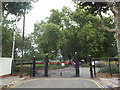
There are currently over 7.5m images from over14,400 individuals and you can help contribute to the project by visiting https://www.geograph.org.uk
Image Map (Loading...)


Getting Data...Please wait
Leaflet Map data © OpenStreetMap
Images are licensed for reuse under creativecommons.org/licenses/by-sa/2.0
Notes
- Clicking on the map will re-center to the selected point.
- The higher the marker number, the further away the image location is from the centre of the postcode.
Image Listing (57 Images Found)
Images are licensed for reuse under creativecommons.org/licenses/by-sa/2.0
Image
Details
Distance
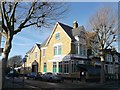
1
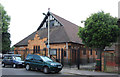
St Andrew, Rutland Road - Now Greek Orthodox St Lazarus & St Andrew
Image: © John Salmon
Taken: 11 Jun 2014
0.08 miles
2
St Andrew, Rutland Road
Now a Greek Orthodox - St Lazarus & St Andrew
Image: © John Salmon
Taken: 11 Jun 2014
0.08 miles
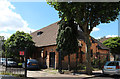
3
East Ham Care Centre, Plashet
A modern care centre built behind Image
Image: © David Anstiss
Taken: 16 Dec 2012
0.10 miles
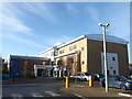
4
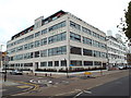
The Summitt Practice, Plashet
On Shrewsbury Road.
This was East Ham Memorial Hospital. But other large hospitals have been built so de-grading this hospital to a doctors practice. A modern Care Centre has been built behind the practice building.
Image: © David Anstiss
Taken: 16 Dec 2012
0.11 miles
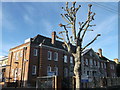
5
Plashet Park, near East Ham
Plashet Park is a small park in the east London suburbs.
Image: © Malc McDonald
Taken: 3 Sep 2017
0.11 miles
6
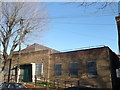
Former sweets factory near Forest Gate
Signwriting on the exterior of this building indicates that it had been a sweets factory.
It was built in 1935 for the Trebor company, sweets were produced here until 1981. The building has since been converted into apartments.
For a detailed history of the site, and of the Trebor company, go to the E7 Now & Then website: http://www.e7-nowandthen.org/2014/04/the-trebor-story-forest-gates-sweet.html
Image: © Malc McDonald
Taken: 3 Sep 2017
0.12 miles
7
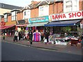
Sarees and Spices in East Ham
The saree and spice shops of East Ham provide a colourful display. This is Green Street, E7.
Image: © John Davies
Taken: 24 Jan 2006
0.12 miles
8
Disused Church, Upton Park
On Edith Road.
Has a foundation stone with engraving. 'This stone was laid by Dr L.Comyns J.P. Chairman West Ham Hospital Management Committee 19th February 1953'
Image: © David Anstiss
Taken: 16 Dec 2012
0.13 miles
9
Masjid-e-Quba, Plashet
Islamic Education and Cultural Centre on the junction of Stafford Road and Shrewsbury Road.
In a converted house.
Image: © David Anstiss
Taken: 16 Dec 2012
0.13 miles
10

Extreme pruning, Shrewsbury Road (2)
These large plane trees are being trimmed and the prunings are being chipped.
See Image for a wider view.
Image: © David Anstiss
Taken: 16 Dec 2012
0.14 miles