IMAGES TAKEN NEAR TO
Mile End Road, LONDON, E3 4LH
Introduction
This page details the photographs taken nearby to Mile End Road, E3 4LH by members of the Geograph project.
The Geograph project started in 2005 with the aim of publishing, organising and preserving representative images for every square kilometre of Great Britain, Ireland and the Isle of Man.

There are currently over 7.5m images from over14,400 individuals and you can help contribute to the project by visiting https://www.geograph.org.uk
Image Map
Images are licensed for reuse under creativecommons.org/licenses/by-sa/2.0
Notes
- Clicking on the map will re-center to the selected point.
- The higher the marker number, the further away the image location is from the centre of the postcode.
Image Listing (264 Images Found)
Images are licensed for reuse under creativecommons.org/licenses/by-sa/2.0
Image
Details
Distance

2

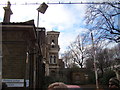
View of the John Denham Building of St Clement's Hospital from the entrance road
This is the building of St Clement's Hospital that faces Bow Road, looking south-southwest from the main entrance road of the hospital. If you're wondering how I got access into the site (the site has been closed to the public since 2005), I have two friends from university who are working on a project to convert the hospital site into a Community Land Trust, passed by Boris Johnson last year. Read more about it here: http://www.jtp.co.uk/community-planning-projects/st-clements/
Image: © Robert Lamb
Taken: 1 Dec 2012
0.00 miles
3
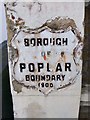
Old Boundary Marker by the A11, Bow Road E3
Municipal Boundary Marker by the A11, in parish of Poplar (Tower Hamlets District), Bow Road E3, on pier next to pharmacy 50m East of junction with Brokesley Street. Metal plate faces West along Bow Road.
Inscription reads:- : BOROUGH / OF / POPLAR / BOUNDARY / 1900 :
Surveyed
Milestone Society National ID: MX_POPL01pb.
Image: © Milestone Society
Taken: Unknown
0.01 miles
5
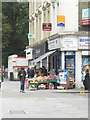
Shop on the corner of Brokesley Street
Image: © Andrew Wilson
Taken: 22 Sep 2013
0.01 miles
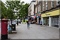
6
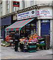
Mile End Cash & Carry
One of the staff surveys the stock outside the shop in the run up to lunchtime.
Image: © Martin Addison
Taken: 15 May 2015
0.01 miles
7
View of the John Denham Building of St Clement's Hospital from the entrance road #2
Looking south-southwest. If you're wondering how I got access into the site (the site has been closed to the public since 2005), I have two friends from university who are working on a project to convert the hospital site into a Community Land Trust, passed by Boris Johnson last year. Read more about it here: http://www.jtp.co.uk/community-planning-projects/st-clements/
Image: © Robert Lamb
Taken: 1 Dec 2012
0.02 miles
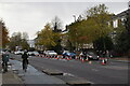
8
Mile End Road
A view of the broad pavement beside the A11.
Image: © Martin Addison
Taken: 15 May 2015
0.02 miles
9
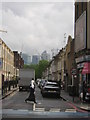
Brokesley St, E3
In the distance, the towers of Canary Wharf on the Isle of Dogs.
Image: © Christopher Hilton
Taken: 11 May 2016
0.02 miles
