IMAGES TAKEN NEAR TO
Railway Arches, Burdett Road, LONDON, E3 4JS
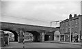
Introduction
This page details the photographs taken nearby to Railway Arches, Burdett Road, E3 4JS by members of the Geograph project.
The Geograph project started in 2005 with the aim of publishing, organising and preserving representative images for every square kilometre of Great Britain, Ireland and the Isle of Man.

There are currently over 7.5m images from over14,400 individuals and you can help contribute to the project by visiting https://www.geograph.org.uk
Image Map
Images are licensed for reuse under creativecommons.org/licenses/by-sa/2.0
Notes
- Clicking on the map will re-center to the selected point.
- The higher the marker number, the further away the image location is from the centre of the postcode.
Image Listing (133 Images Found)
Images are licensed for reuse under creativecommons.org/licenses/by-sa/2.0
Image
Details
Distance
1
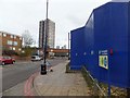
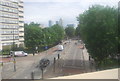
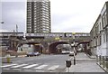
Burdett Road
The road runs underneath the railway line from Limehouse to the north-east. The blue screen surrounds construction work for the Crossrail link.
Image: © David Smith
Taken: 20 Nov 2012
0.01 miles
2
Bridge Demolition, Burdett Road, Bow
In 1984 the bridge carrying the Liverpool Street to East Anglia railway line at Burdett Road was being demolished to facilitate a road widening scheme. The new steel bridge waits on the far side ready to be pushed into position when required. See Image
Image: © Derek Voller
Taken: Unknown
0.02 miles
3
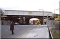
Demolition of Burdett Road railway bridge Bow
A new steel bridge awaits the removal of the old Victorian brick bridge before being slid forward and secured to restore the Liverpool Street line to East Anglia. The work was part of a road widening scheme to improve the flow of traffic between Limehouse and Mile End.
Image: © Derek Voller
Taken: Unknown
0.02 miles
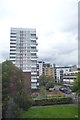
4
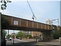
Railway on Burdett Road, Bow Common
Burdett Road leads from Limehouse towards Mile End.
It passes under the railway between Stratford and Limehouse (and London).
Image: © David Anstiss
Taken: 23 May 2012
0.02 miles
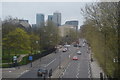
5
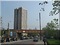
Railway on Burdett Road, Bow Common
Burdett Road leads from Mile End towards Limehouse.
In the background is a tower block of housing on Ackroyd Drive.
Further back is Canary Wharf in the Isle of Dogs.
Image: © David Anstiss
Taken: 23 May 2012
0.02 miles
7
Site of Burdett Road Station
View NW along Burdett Road: the station had been on the left but was closed 21/4/41 - no doubt owing to Blitz damage. This is the ex-Great Eastern line from Fenchurch St. to Stratford, which was not used Gas Factory Jct. - Bow Jct. after 1949, but remained the main line of the Tilbury Lines (ex-London, Tilbury & Southend), electrified in 1962.
Image: © Ben Brooksbank
Taken: 25 Mar 1962
0.04 miles