IMAGES TAKEN NEAR TO
Makers Yard, LONDON, E3 3YL
Introduction
This page details the photographs taken nearby to Makers Yard, E3 3YL by members of the Geograph project.
The Geograph project started in 2005 with the aim of publishing, organising and preserving representative images for every square kilometre of Great Britain, Ireland and the Isle of Man.

There are currently over 7.5m images from over14,400 individuals and you can help contribute to the project by visiting https://www.geograph.org.uk
Image Map (Loading...)


Getting Data...Please wait
Leaflet Map data © OpenStreetMap
Images are licensed for reuse under creativecommons.org/licenses/by-sa/2.0
Notes
- Clicking on the map will re-center to the selected point.
- The higher the marker number, the further away the image location is from the centre of the postcode.
Image Listing (115 Images Found)
Images are licensed for reuse under creativecommons.org/licenses/by-sa/2.0
Image
Details
Distance
1
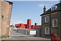
View of a container city in the Veolia offices on Gillender Street
Looking north-northeast.
Image: © Robert Lamb
Taken: 5 Jun 2016
0.01 miles
2
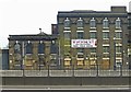
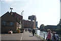
Nineteenth century warehouse, with ghost sign, Bromley-by-Bow
Grade II listed building, known as Dowgate Wharf of P.B. Burgoyne, and later Aplin's Distillery (hence the lettering on the facade). A rare survivor.
Image: © Jim Osley
Taken: 24 Apr 2015
0.02 miles
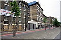
5
View of new apartments on Gillender Street from Navigation Road
Looking south-southwest.
Image: © Robert Lamb
Taken: 5 Jun 2016
0.03 miles
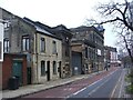
6
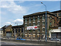
Warehouse, Gillender Street (1)
An unusually refined design, almost like a muscular Georgian manor house. The facade is articulated by giant piers which meet at the top to form a continuous arcade, a theme which is continued in the low block on the left. The whole thing was built mid C19th for P.B. Burgoyne & Co. Ltd, although the fading writing on the front reads 'Aplins spirits and liqueur'. Grade II listed.
It is empty at present and clearly in need of a new owner.
Paul Smith, who lived in the area shortly after the war, told me that "from 1937 the building was used by the Emu Wine Company", for an unspecified period, and that "the words can be seen, although faint". Also, "the two buildings on the extreme left, after the metal gate, were known as the Emu cottages and on the brick one can still be seen "WIN" as in wine."
Image: © Stephen Richards
Taken: 4 Jun 2011
0.03 miles
7
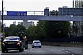
Blackwall Tunnel Northern Approach (A12)
Image: © Steve Daniels
Taken: 1 Oct 2022
0.03 miles
8
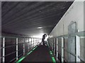
Floating towpath carried under the dual carriageway
The authorities have been very thoughtful in adding illumination to the path as it is carried under the roadway.
Image: © John Reeves
Taken: 27 Jan 2010
0.03 miles
9
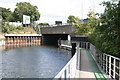
Blackwall Tunnel Northern Approach Road bridge over Limehouse Cut
We are looking northeast here. The scene is very much changed since World War II. Before the changes, there was just a small bridge here, called Four Mills Bridge, crossed by a road known as St. Leonards Street. Just beyond the bridge was a lock, Bromley Lock. The works, involving construction of a large dual-carriageway road, entailed removal of the lock and towpath, and for many years access to the Limehouse Cut towpath was not possible here. But in 2004, a new floating towpath (edged in green) was constructed - it won a design award.
Image: © Dr Neil Clifton
Taken: 3 Sep 2008
0.03 miles
10
View back up Gillender Street
Looking north back towards Stratford.
Image: © Robert Lamb
Taken: 5 Jun 2016
0.03 miles