IMAGES TAKEN NEAR TO
St. Andrews Way, LONDON, E3 3PA
Introduction
This page details the photographs taken nearby to St. Andrews Way, E3 3PA by members of the Geograph project.
The Geograph project started in 2005 with the aim of publishing, organising and preserving representative images for every square kilometre of Great Britain, Ireland and the Isle of Man.

There are currently over 7.5m images from over14,400 individuals and you can help contribute to the project by visiting https://www.geograph.org.uk
Image Map
Images are licensed for reuse under creativecommons.org/licenses/by-sa/2.0
Notes
- Clicking on the map will re-center to the selected point.
- The higher the marker number, the further away the image location is from the centre of the postcode.
Image Listing (108 Images Found)
Images are licensed for reuse under creativecommons.org/licenses/by-sa/2.0
Image
Details
Distance
1

Part of the Old Devons Road locomotive depot
London Docklands railway now passes the site which has been obliterated
Image: © John Firth
Taken: Unknown
0.04 miles
3
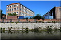
Industrial building near Limehouse Cut
It would appear to be originally used for some labour-intensive industry, but is now a part of a site split up into a multitude of small businesses. It is currently the home of the Limehouse Arts Foundation, and before that an annex of Poplar Technical College.
Image: © Robin Webster
Taken: 11 Dec 2010
0.08 miles

5
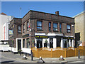
Bromley-by-Bow : "The Beehive" public house
Image: © Jim Osley
Taken: 6 May 2020
0.09 miles
7
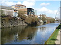
The Limehouse Cut
The Limehouse Cut was built in 1770 to connect the River Lea to the Thames and so shorten the journey for vessels travelling from the River Lea to the Pool of London. It did this by cutting out several loops of the lower Lea and the Thames. In the 19th century it was so polluted that "no bargee who fell in had any chance of surviving his ducking in the filthy water".
The Limehouse Cut was closed to pedestrians for many years but the towpath has been opened up in the last few years so that it is now possible to walk from Limehouse Basin to Three Mills via the new bridge under the Blackwall Tunnel approach road.
Image: © Marathon
Taken: 26 Feb 2014
0.10 miles
8

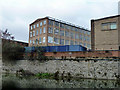
Limehouse Cut
The canal (see also http://www.geograph.org.uk/search.php?i=18757043) runs across the southeast corner of the square. On the right is the four-storey building shown in Image, which is mapped as the Poplar Centre of Hackney College, but since 1994 it has been the home of the Limehouse Arts Foundation http://www.limehouseartsfoundation.org/pages/about.html .
Image: © Derek Harper
Taken: 12 Jan 2011
0.10 miles
9

Devons Road station
Heading towards Poplar on the Docklands Light Railway. Here the route uses the formation of the old North London Railway.
Image: © Robin Webster
Taken: 29 Jan 2011
0.10 miles
