IMAGES TAKEN NEAR TO
Furze Street, LONDON, E3 3AQ
Introduction
This page details the photographs taken nearby to Furze Street, E3 3AQ by members of the Geograph project.
The Geograph project started in 2005 with the aim of publishing, organising and preserving representative images for every square kilometre of Great Britain, Ireland and the Isle of Man.

There are currently over 7.5m images from over14,400 individuals and you can help contribute to the project by visiting https://www.geograph.org.uk
Image Map (Loading...)


Getting Data...Please wait
Leaflet Map data © OpenStreetMap
Images are licensed for reuse under creativecommons.org/licenses/by-sa/2.0
Notes
- Clicking on the map will re-center to the selected point.
- The higher the marker number, the further away the image location is from the centre of the postcode.
Image Listing (80 Images Found)
Images are licensed for reuse under creativecommons.org/licenses/by-sa/2.0
Image
Details
Distance
1
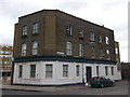
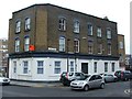
The Earl of Devon, former public house, Bow Common
Converted pub now block of flats on the junction of Devons Road (on the left) and Furze Street (on the right).
Image: © David Anstiss
Taken: 15 Feb 2012
0.03 miles
3
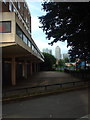
Furze Green
On the corner of Devons Road and Gale Street the garages at the rear of Mollis House lead towards Furze Green. About a mile further south lies the Canary Wharf development.
Image: © Peter Thwaite
Taken: 16 Aug 2008
0.04 miles
4
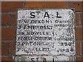
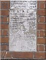
Old Boundary Marker by the B140, St Paul's Way, Poplar
Parish Boundary Marker by the B140, in parish of Poplar (Tower Hamlets District), St Paul's Way E3, near junction with Bow Common Lane, set in wall of RC church above MX_SAL02pb Image
Surveyed
Milestone Society National ID: MX_SAL01pb
Image: © Milestone Society
Taken: Unknown
0.05 miles
5
Old Boundary Marker by the B140, St Paul's Way, Poplar
Parish Boundary Marker by the B140, in parish of Poplar (Tower Hamlets District), St Paul's Way E3, near junction with Bow Common Lane, wall of RC church below MX_SAL01pb Image
Surveyed
Milestone Society National ID: MX_SAL02pb
Image: © Milestone Society
Taken: Unknown
0.05 miles
6
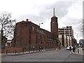
Vietnamese Catholic Church, Bow
Large church on the junction of St Paul's Way (on the right) and Bow Common Lane (on the left).
Image: © David Anstiss
Taken: 15 Feb 2012
0.05 miles
7
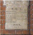
Old Boundary Marker by the B140, St Paul's Way, Poplar Parish
Parish Boundary Marker by the B140, in parish of Poplar (Tower Hamlets District), St Paul's Way E3, junction with Bow Common Lane, on wall of RC church below MX_BSL05pb Image
Surveyed
Milestone Society National ID: MX_BSL06pb
Image: © Milestone Society
Taken: Unknown
0.05 miles
8
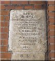
Old Boundary Marker by the B160, St Paul's Way, Poplar Parish
Parish Boundary Marker by the B140, in parish of Poplar (Tower Hamlets District), St Paul's Way E3, junction of Bow Common Lane, on wall of RC church, above MX_BSL06pb Image
Surveyed
Milestone Society National ID: MX_BSL05pb
Image: © Milestone Society
Taken: Unknown
0.05 miles
9
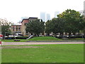
Furze Green and Hawgood Street, London E3
From the 1860s to the 2nd World War this area was densely covered in small houses. Since then it has been totally redeveloped with a green space surrounded by apartments. The new financial district towers of Canary Wharf, seen mistily behind Hawgood Street, have changed the area even more.
Image: © David Hawgood
Taken: 10 Oct 2015
0.06 miles
10
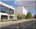
Bow, St Pauls Way Trust School
The main entrance, on St Pauls Way. http://www.spwt.net/default.htm
Image: © Mike Faherty
Taken: 26 Aug 2012
0.07 miles