IMAGES TAKEN NEAR TO
Fairfield Road, LONDON, E3 2UH
Introduction
This page details the photographs taken nearby to Fairfield Road, E3 2UH by members of the Geograph project.
The Geograph project started in 2005 with the aim of publishing, organising and preserving representative images for every square kilometre of Great Britain, Ireland and the Isle of Man.

There are currently over 7.5m images from over14,400 individuals and you can help contribute to the project by visiting https://www.geograph.org.uk
Image Map
Images are licensed for reuse under creativecommons.org/licenses/by-sa/2.0
Notes
- Clicking on the map will re-center to the selected point.
- The higher the marker number, the further away the image location is from the centre of the postcode.
Image Listing (144 Images Found)
Images are licensed for reuse under creativecommons.org/licenses/by-sa/2.0
Image
Details
Distance
1

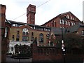
Former Bryant & May match factory, Bow
A grade II listed building of 1908-10.
Image: © Robin Webster
Taken: 11 Dec 2010
0.03 miles
2

View of the former Bryant & May factory from the Greenway
Looking south-southwest.
Image: © Robert Lamb
Taken: 8 Jan 2012
0.04 miles
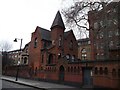
3
Fairfield Match Works, Bow
Former Bryant and May factory on Fairfield Road.
Was the setting of the 'London matchgirls strike of 1888'.
Most of the buildings have been converted into housing - creating the Bow Quarter Estate.
See http://en.wikipedia.org/wiki/London_matchgirls_strike_of_1888 for more details about the strike.
All of the buildings are Grade II listed. Including http://www.britishlistedbuildings.co.uk/en-205964-fairfield-match-works-bryant-and-may-bow the large red-brick building in the background.
Image: © David Anstiss
Taken: 15 Feb 2012
0.04 miles
4

Railway lines to Liverpool Street outside Pudding Mill Lane station, viewed from Marshgate Lane
Looking north-northeast. The large brick building in the background is the former Bryant & May match factory on Wick Lane, adjacent to the A102(M) Blackwall Tunnel Approach, now part of the Bow Quarter Estate.
Image: © Robert Lamb
Taken: 8 Jan 2012
0.04 miles
5

View of the former Bryant & May match factory (Bow Quarter Estate) from the River Lea
Looking south-southwest.
Image: © Robert Lamb
Taken: 5 Jun 2016
0.04 miles
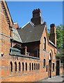
6
Fairfield Match Works 1 and 1a, Bow
A Grade II listed building on Fairfield Road. The main factory building is in the background. All have been converted into housing.
See http://www.britishlistedbuildings.co.uk/en-205966-fairfield-match-works-1-and-1a-bow for more details about the building.
Image: © David Anstiss
Taken: 15 Feb 2012
0.05 miles
7

Blue Plaque for Annie Besant
On Image
See http://en.wikipedia.org/wiki/London_matchgirls_strike_of_1888 for more details about the strike.
See also http://en.wikipedia.org/wiki/Annie_Besant for more details about the strike breaker.
Image: © David Anstiss
Taken: 15 Feb 2012
0.06 miles
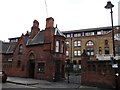
8
Bow Quarter perimeter wall
Bow Quarter is a gated housing complex developed from the Bryant and May match factory in Fairfield Road, Bow. The site is an important site in labour and union history, for it here in 1888 that the match girls, organised by Annie Beasant, went on strike. The perimeter wall shown in the image is Grade II listed - https://historicengland.org.uk/listing/the-list/list-entry/1065188.
Image: © Jim Osley
Taken: 10 May 2020
0.06 miles
9
Entrance Gate to Fairfield Match Works, Bow
Former Bryant and May factory on Fairfield Road.
Was the setting of the 'London matchgirls strike of 1888'.
Most of the buildings have been converted into housing - creating the Bow Quarter Estate.
See http://en.wikipedia.org/wiki/London_matchgirls_strike_of_1888 for more details about the strike.
All of the buildings are Grade II listed. Including http://www.britishlistedbuildings.co.uk/en-205967-fairfield-match-works-2-bow at the entrance.
See also Image, (close-up of the blue plaque on the building).
Image: © David Anstiss
Taken: 15 Feb 2012
0.06 miles
10

Fairfield Road from under the railway bridge
This is one of two rail bridges in quick succession
Image: © David Howard
Taken: 11 Jul 2012
0.07 miles