IMAGES TAKEN NEAR TO
Ollerton Green, LONDON, E3 2LB
Introduction
This page details the photographs taken nearby to Ollerton Green, E3 2LB by members of the Geograph project.
The Geograph project started in 2005 with the aim of publishing, organising and preserving representative images for every square kilometre of Great Britain, Ireland and the Isle of Man.

There are currently over 7.5m images from over14,400 individuals and you can help contribute to the project by visiting https://www.geograph.org.uk
Image Map
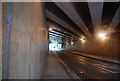
Images are licensed for reuse under creativecommons.org/licenses/by-sa/2.0
Notes
- Clicking on the map will re-center to the selected point.
- The higher the marker number, the further away the image location is from the centre of the postcode.
Image Listing (303 Images Found)
Images are licensed for reuse under creativecommons.org/licenses/by-sa/2.0
Image
Details
Distance
2

Monier Road at the junction of Wick Lane
The East Cross Route to Blackwall Tunnel is on the right
Image: © David Howard
Taken: 11 Jul 2012
0.05 miles
3
Wick Lane
Looking down Wick Lane, with the chimney of the former Wick Lane Works, now a storage site, in the background.
Image: © Ian Capper
Taken: 13 Jul 2019
0.06 miles
4
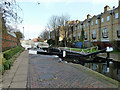
Middle lock, Hertford Union Canal
There are three locks taking the canal from Lee Navigation to Regents Canal level. There are remains of a fourth at the west end, but it could only have been a stop lock.
Image: © Robin Webster
Taken: 11 Dec 2010
0.06 miles
5
Hertford Union Middle Lock
Lush summer vegetation gently dripping in the June drizzle.
Image: © David Martin
Taken: 20 Jun 2021
0.06 miles
6
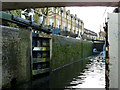
Hertford Union Canal middle lock
Looking from under Wick Lane Bridge.
Image: © Robin Webster
Taken: 11 Dec 2010
0.06 miles
7
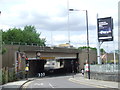
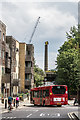
Bridge under the East Cross Route near Hackney Wick
This bridge carries the busy A12 road over a local road. The bridge has limited headroom - the signs prohibit any vehicle taller than 12'9" from attempting to pass beneath it.
Image: © Malc McDonald
Taken: 25 May 2013
0.06 miles
10
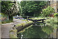
Hertford Union Canal filling up with water
The Hertford Union Canal was opened in 1830 to connect the Regent's Canal with the Lee Navigation, and was originally known as Duckett's Canal after Sir George Duckett who financed its construction. It has three locks, all towards its eastern end Old Ford Top Lock, Middle Lock and Bottom Lock.
This view looks from near Old Ford Top Lock towards Old Ford Middle Lock. A few minutes earlier this section was only a couple of feet deep after a boat had passed through, but now water was rapidly filling it by pouring through the gates of the Top Lock. See http://www.geograph.org.uk/photo/4002235 The houses on the right are in Jodrell Road.
Image: © Marathon
Taken: 28 May 2014
0.06 miles