IMAGES TAKEN NEAR TO
Goldsmiths Row, LONDON, E2 8QU
Introduction
This page details the photographs taken nearby to Goldsmiths Row, E2 8QU by members of the Geograph project.
The Geograph project started in 2005 with the aim of publishing, organising and preserving representative images for every square kilometre of Great Britain, Ireland and the Isle of Man.

There are currently over 7.5m images from over14,400 individuals and you can help contribute to the project by visiting https://www.geograph.org.uk
Image Map (Loading...)


Getting Data...Please wait
Leaflet Map data © OpenStreetMap
Images are licensed for reuse under creativecommons.org/licenses/by-sa/2.0
Notes
- Clicking on the map will re-center to the selected point.
- The higher the marker number, the further away the image location is from the centre of the postcode.
Image Listing (388 Images Found)
Images are licensed for reuse under creativecommons.org/licenses/by-sa/2.0
Image
Details
Distance
2
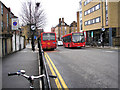
Buses on Pritchard's Road
Looking south from Cat & Mutton Bridge, two buses on Route 394 are seen passing near the northern end of Pritchard's Road. Route 394 operates from the 'Angel', Islington, to Homerton Hospital, mainly using roads which are not served by other routes.
Image: © Dr Neil Clifton
Taken: 25 Feb 2010
0.01 miles
3
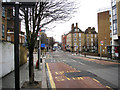
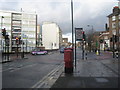
Pritchard's Road
Looking south from Cat & Mutton Bridge, at the traffic lights Whiston Road comes in from the right, while Pritchard's Road veers left. The narrower road going straight on is Goldsmith's Row. In this picture, the boundary between the London Boroughs of Hackney and Tower Hamlets lies along the centre of Pritchard's Road, with Tower Hamlets to the left and Hackney to the right.
Image: © Dr Neil Clifton
Taken: 25 Feb 2010
0.01 miles
4
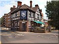
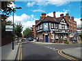
The Albion in Goldsmith Row
The Albion in Goldsmith's Row is hugely popular among Shoreditch locals and has established itself as a base for supporters of West Bromwich Albion FC http://www.viewlondon.co.uk/pubsandbars/the-albion-info-15895.html
Image: © Paul Gillett
Taken: 4 Jun 2011
0.05 miles
6
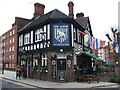
The Albion, Haggerston
The Albion pub in Haggerston, in inner east London.
Image: © Malc McDonald
Taken: 17 Jul 2016
0.05 miles
7
The Albion in Goldsmiths Row, Bethnal Green
Image: © Chris Whippet
Taken: 25 Jan 2015
0.05 miles
8
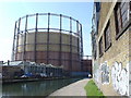
Gasholder on the Regent's Canal
Near Mare Street, Hackney.
Image: © dg
Taken: 3 Apr 2005
0.06 miles
9
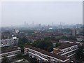
Flats, I assume
Taken from the 16th floor of a 17 floor block of flats.
Image: © Timothy Baldwin
Taken: 15 Oct 2006
0.06 miles
10
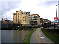
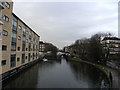
Flats along the Regent's Canal
These four blocks of flats have been given canal-related names: from the near end, they are: Imperial Wharf, Alexandra Wharf, London Wharf, and Regents Wharf. The flats are all in the London Borough of Tower Hamlets, but the photographer on the towpath is in Hackney.
Image: © Dr Neil Clifton
Taken: 25 Feb 2010
0.06 miles