IMAGES TAKEN NEAR TO
Pelter Street, LONDON, E2 7PE
Introduction
This page details the photographs taken nearby to Pelter Street, E2 7PE by members of the Geograph project.
The Geograph project started in 2005 with the aim of publishing, organising and preserving representative images for every square kilometre of Great Britain, Ireland and the Isle of Man.

There are currently over 7.5m images from over14,400 individuals and you can help contribute to the project by visiting https://www.geograph.org.uk
Image Map
Images are licensed for reuse under creativecommons.org/licenses/by-sa/2.0
Notes
- Clicking on the map will re-center to the selected point.
- The higher the marker number, the further away the image location is from the centre of the postcode.
Image Listing (423 Images Found)
Images are licensed for reuse under creativecommons.org/licenses/by-sa/2.0
Image
Details
Distance
1

Haggerston: 'Ye Olde Axe', 69 Hackney Road
Very much an open living pub. A boy was just putting out a sign saying, 'All pints £2' - and I'm willing to wager there would be real cask ale. By the way, the clock is wrong - it was morning, but not that early!
Image: © Dr Neil Clifton
Taken: 2 Feb 2010
0.01 miles
2

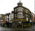
Shoreditch: 'The Conqueror'
At the extreme northern end of Boundary Street*, where it meets Austin Street. There are many pubs in Britain named after a monarch, and they seem to be roughly counted proportionately to the popularity of the monarch concerned, with Victoria and William IV high on the list. Not many are named after William I, (after all, he was a Frenchman who came here uninvited, and tried to make us all speak French), but this one on the fringes of Shoreditch, is one example. However, it now appears to be an ex-pub, although retaining its name and sign.
*So named because it runs along the boundary between Shoreditch and Bethnal Green. However, the extreme northern end did not run along the boundary, and was at first named 'Broadway' - although, of course, it was not very broad at all.
Image: © Dr Neil Clifton
Taken: 2 Feb 2010
0.02 miles
3

Haggerston: Hackney Road and 'Joiner's Arms'
Looking east along the south side of Hackney Road, the second building along is the 'Joiner's Arms'. The small street off on the right is Strouts Place.
Image: © Dr Neil Clifton
Taken: 3 Feb 2010
0.04 miles
4

Haggerston: Hackney Road, south side
The road down to the left is Hassard Street
Image: © Dr Neil Clifton
Taken: 3 Feb 2010
0.05 miles
6
Haggerston: 61 Hackney Road
This was a public house as originally built, probably about 1890, and named 'The Duke of Clarence'. It is at the junction of Hackney Road with Waterson Road. I am indebted to Brian Ward of New Zealand for this information.
Image: © Dr Neil Clifton
Taken: 2 Feb 2010
0.06 miles
7
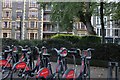
Santander bikes on Columbia Road, Shoreditch
Image: © David Howard
Taken: 28 Sep 2019
0.06 miles
8
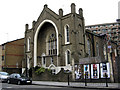
Haggerston: Former church, Hackney Road
Built probably around 1860 as a Wesleyan Methodist church, this building appears to be out of use but undergoing refurbishment.
Image: © Dr Neil Clifton
Taken: 3 Feb 2010
0.06 miles
9
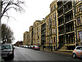
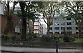
Shoreditch: Columbia Road
Columbia Road runs eastwards from Hackney Road, and is part of the B211. It has these magnificent six-story houses, which are now all subdivided.
Image: © Dr Neil Clifton
Taken: 2 Feb 2010
0.06 miles
10
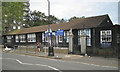
Columbia Market Nursery School, E2
By the western part of Columbia Road, B118. The gate pillars say that there was once something else on this site.
Image: © Robin Stott
Taken: 10 Jun 2012
0.06 miles