IMAGES TAKEN NEAR TO
Virginia Road, LONDON, E2 7NF
Introduction
This page details the photographs taken nearby to Virginia Road, E2 7NF by members of the Geograph project.
The Geograph project started in 2005 with the aim of publishing, organising and preserving representative images for every square kilometre of Great Britain, Ireland and the Isle of Man.

There are currently over 7.5m images from over14,400 individuals and you can help contribute to the project by visiting https://www.geograph.org.uk
Image Map
Images are licensed for reuse under creativecommons.org/licenses/by-sa/2.0
Notes
- Clicking on the map will re-center to the selected point.
- The higher the marker number, the further away the image location is from the centre of the postcode.
Image Listing (781 Images Found)
Images are licensed for reuse under creativecommons.org/licenses/by-sa/2.0
Image
Details
Distance
1
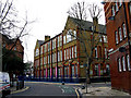
Bethnal Green: Virginia School, Arnold Circus
Image: © Dr Neil Clifton
Taken: 3 Feb 2010
0.02 miles
2
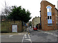
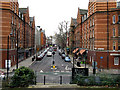
Bethnal Green: Hocker Street from Arnold Circus
Hocker Street is a short street which runs north from Arnold Circus to a T-junction with Virginia Road at the end of Austin Street.
Image: © Dr Neil Clifton
Taken: 3 Feb 2010
0.02 miles
3
Bethnal Green: Virginia Road, looking west
Taken from the north end of Hocker Street. This part of Virginia Road was originally Castle Street, later Old Castle Street. At the far (west) end, it makes a junction with Boundary Street, at the back of St. Leonard's Church - the Shoreditch boundary has been reached at this point.
Image: © Dr Neil Clifton
Taken: 3 Feb 2010
0.02 miles
4
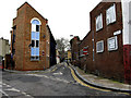
Bethnal Green: Austin Street
Looking east from the north end of Hocker Street, where Austin Street makes a junction with Virginia Road. From here, Austin Street's course leads westwards until it reaches Hackney Road. This narrow street is a one-way street, for west to east traffic.
Image: © Dr Neil Clifton
Taken: 3 Feb 2010
0.03 miles
5
Bethnal Green: Calvert Avenue from Arnold Circus
Calvert Avenue, Arnold Circus and Club Row are part of the B122. The bus seen approaching is on Route 78. This has come from Nunhead and is nearing its northern terminus at Arnold Circus.
Image: © Dr Neil Clifton
Taken: 3 Feb 2010
0.03 miles
6
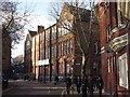
A terrace of two storey workshops, off Arnold Circus
Around the focal Arnold Circus in a development designed by Owen Fleming & W.E. Riley as lead architects with the LCC. Built 1894-1900 the Boundary Estate was opened by His Majesty King Edward VII and remains a paradigm of urban design
with two schools, workshop terraces and retail shops along Calvert Avenue.
Image: © Colin D Brooking
Taken: 30 Nov 2014
0.03 miles
7
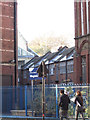
Virginia Primary School facing Arnold Circus
Around the focal Arnold Circus in a development designed by Owen Fleming & W.E. Riley as lead architects with the LCC. Built 1894-1900 the Boundary Estate was opened by His Majesty King Edward VII and remains a paradigm of urban design
with two schools, workshop terraces and retail shops along Calvert Avenue.
Image: © Colin D Brooking
Taken: 30 Nov 2014
0.04 miles
8
Calvert Avenue corner with Virginia Road
Around the focal Arnold Circus in a development designed by Owen Fleming & W.E. Riley as lead architects with the LCC. Built 1894-1900 the Boundary Estate was opened by His Majesty King Edward VII and remains a paradigm of urban design
with two schools, workshop terraces and retail shops along Calvert Avenue.
Image: © Colin D Brooking
Taken: 30 Nov 2014
0.04 miles
9
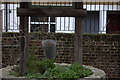
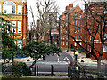
Ornamental "well" in St Leonard's churchyard
Image: © Robert Eva
Taken: 23 Jan 2018
0.04 miles
10
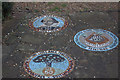
Shakespeare mosaics in St Leonard's churchyard
Image: © Robert Eva
Taken: 23 Jan 2018
0.04 miles