IMAGES TAKEN NEAR TO
Calvert Avenue, LONDON, E2 7JL
Introduction
This page details the photographs taken nearby to Calvert Avenue, E2 7JL by members of the Geograph project.
The Geograph project started in 2005 with the aim of publishing, organising and preserving representative images for every square kilometre of Great Britain, Ireland and the Isle of Man.

There are currently over 7.5m images from over14,400 individuals and you can help contribute to the project by visiting https://www.geograph.org.uk
Image Map (Loading...)


Getting Data...Please wait
Leaflet Map data © OpenStreetMap
Images are licensed for reuse under creativecommons.org/licenses/by-sa/2.0
Notes
- Clicking on the map will re-center to the selected point.
- The higher the marker number, the further away the image location is from the centre of the postcode.
Image Listing (962 Images Found)
Images are licensed for reuse under creativecommons.org/licenses/by-sa/2.0
Image
Details
Distance
1
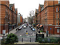
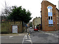
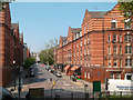
Bethnal Green: Calvert Avenue from Arnold Circus
Calvert Avenue, Arnold Circus and Club Row are part of the B122. The bus seen approaching is on Route 78. This has come from Nunhead and is nearing its northern terminus at Arnold Circus.
Image: © Dr Neil Clifton
Taken: 3 Feb 2010
0.01 miles
2
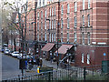
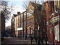
A terrace of two storey workshops, off Arnold Circus
Around the focal Arnold Circus in a development designed by Owen Fleming & W.E. Riley as lead architects with the LCC. Built 1894-1900 the Boundary Estate was opened by His Majesty King Edward VII and remains a paradigm of urban design
with two schools, workshop terraces and retail shops along Calvert Avenue.
Image: © Colin D Brooking
Taken: 30 Nov 2014
0.01 miles
3
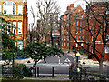
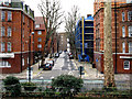
Calvert Avenue retail shops & cafe parade
Around the focal Arnold Circus in a development designed by Owen Fleming & W.E. Riley as lead architects with the LCC. Built 1894-1900 the Boundary Estate was opened by His Majesty King Edward VII and remains a paradigm of urban design
with two schools, workshop terraces and retail shops along Calvert Avenue.
Image: © Colin D Brooking
Taken: 30 Nov 2014
0.01 miles
4
Bethnal Green: Hocker Street from Arnold Circus
Hocker Street is a short street which runs north from Arnold Circus to a T-junction with Virginia Road at the end of Austin Street.
Image: © Dr Neil Clifton
Taken: 3 Feb 2010
0.02 miles
5
Bethnal Green: Virginia Road, looking west
Taken from the north end of Hocker Street. This part of Virginia Road was originally Castle Street, later Old Castle Street. At the far (west) end, it makes a junction with Boundary Street, at the back of St. Leonard's Church - the Shoreditch boundary has been reached at this point.
Image: © Dr Neil Clifton
Taken: 3 Feb 2010
0.02 miles
6
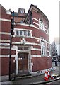
Virginia Primary School facing Arnold Circus
Around the focal Arnold Circus in a development designed by Owen Fleming & W.E. Riley as lead architects with the LCC. Built 1894-1900 the Boundary Estate was opened by His Majesty King Edward VII and remains a paradigm of urban design
with two schools, workshop terraces and retail shops along Calvert Avenue.
Image: © Colin D Brooking
Taken: 30 Nov 2014
0.02 miles
7
Bethnal Green: Navarre Street from Arnold Circus
At its far end, Navarre Street has a T-junction with Boundary Street
Image: © Dr Neil Clifton
Taken: 3 Feb 2010
0.03 miles
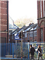
8
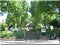
Arnold Circus from Calvert Avenue to the west
The Old Nichol Street Rookery in Bethnal Green was one of the worst and most dangerous slums in Victorian London. The death rate was twice that of the rest of Bethnal Green, and four times that of London. One child in four died before his or her first birthday. A vigorous campaign took place from the 1880s to demolish the area and replace it with something far better. The Boundary Estate, constructed from 1890, was one of the earliest social housing schemes built by a local government authority. It was begun by the Metropolitan Board of Works and completed by the recently formed London County Council. It is, arguably, the world's first council housing. It was formally opened in 1900 by the Prince of Wales, soon to be Edward VIIth. The demolition rubble was used to construct a mound in the middle of Arnold Circus at the centre of the development, housing a bandstand which remains to this day. The estate consists of multi-storey brick tenements radiating from the central circus, which also has six roads radiating from it. The flats and bandstand are now Grade II listed.
Image: © Marathon
Taken: 19 Jun 2013
0.03 miles
10
Calvert Avenue corner with Virginia Road
Around the focal Arnold Circus in a development designed by Owen Fleming & W.E. Riley as lead architects with the LCC. Built 1894-1900 the Boundary Estate was opened by His Majesty King Edward VII and remains a paradigm of urban design
with two schools, workshop terraces and retail shops along Calvert Avenue.
Image: © Colin D Brooking
Taken: 30 Nov 2014
0.03 miles